Xiaobianhe geodata
Xiaobianhe (Shaanxi) is a seat of a fourth-order administrative division; located in China in Asia/Shanghai (GMT+8) time zone. In our database, there are 1268 cities with bigger population. Compared to other cities in China, 67.1% of cities are located further ↓South; 85.2% of cities are located further →East and 79.9% of cities have lower elevation than Xiaobianhe. Note1


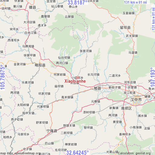
Xiaobianhe GPS coordinates[2]
33° 13' 57.18" North, 106° 29' 23.532" East
| Map corner | latitude | longitude |
|---|---|---|
| Upper-left | 33.8187°, | 105.78675° |
| Center: | 33.23255°, | 106.48987° |
| Lower-right: | 32.64245°, | 107.193° |
| Map W x H: | 130.8×130.8 km | = 81.3×81.3mi |
| max Lat: | 53.31946° ⇑32.9% North |
| Xiaobianhe: | 33.23255° |
| min Lat: | ⇓67.1% South 18.22056° |
| min Long | Xiaobianhe | max Long |
| 75.07348° | 106.48987° | 134.28917° |
| W 14.8%⇐ | ⇒85.2% E |
Elevation
Elevation of Xiaobianhe is 694 m = 2277 ft, and this is 209.2 m = 686 ft above average elevation for this country.
| Max E: |
5622 m = 18445 ft | 20.1% |
| Xiaobianhe | 694 m 2277 ft | |
| Avg. | 484.8 m = 1591 ft | |
Min E: |
-3 m = -10 ft | 79.9% |
See also: China elevation on elevation.city.
Geographical zone
Xiaobianhe is located in North temperate zone (between Tropic of Cancer and the Arctic Circle). Distance of this Northern Tropic circle is 1089.2 km =676.8 mi to South.| Distance of | km | miles | from Xiaobianhe |
|---|---|---|---|
| North Pole | 6311.9 | 3922 | to North |
| Arctic Circle | 3706.1 | 2302.9 | to North |
| Tropic Cancer | 1089.2 | 676.8 | to South |
| Equator | 3695.1 | 2296 | to South |


Nearby cities:
15 places around Xiaobianhe: (largest is in red/bold)
• Chadian
5.6 km =3.5 mi,  208°
208°
• Changgouhe
13.4 km =8.3 mi,  78°
78°
• Dingjunshan
18.9 km =11.7 mi,  123°
123°
• Guanyinsi
15.3 km =9.5 mi,  347°
347°
• Heiheba
4.8 km =3 mi,  243°
243°
• Hejiayan
15.5 km =9.6 mi,  280°
280°
• Lianghekou
18.4 km =11.4 mi,  315°
315°
• Mianyang
20.8 km =12.9 mi,  113°
113°
• Miaoba
17.3 km =10.7 mi,  245°
245°
• Qingyangyi
18.9 km =11.7 mi, 209°
• Tuguanpu
12.7 km =7.9 mi,  153°
153°
• Wuhou
14.8 km =9.2 mi,  128°
128°
• Xiakouyi
8 km =5 mi, 252°
• Xinpu
15.2 km =9.4 mi,  194°
194°
• Yudongzi
18.7 km =11.6 mi,  303°
303°
Sources, notices
• [Note1] Compared only with cities in China existing in our database
• [Src1] Map data: © OpenStreetMap contributors (CC-BY-SA)
• [Src2] Other city data from geonames.org with taken over terms of usage.
• [Src3] Geographical zone / Annual Mean Temperature by Robert A. Rohde @ Wikipedia
