Baqiu geodata
Baqiu (Jiangxi) is a seat of a fourth-order administrative division; located in China in Asia/Shanghai (GMT+8) time zone. In our database, there are 1268 cities with bigger population. Compared to other cities in China, 76.4% of cities are located further ↑North; 55.1% of cities are located further ←West and 69.5% of cities have higher elevation than Baqiu. Note1


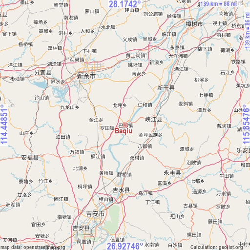
Baqiu GPS coordinates[2]
27° 33' 9.36" North, 115° 9' 5.868" East
| Map corner | latitude | longitude |
|---|---|---|
| Upper-left | 28.1742°, | 114.44851° |
| Center: | 27.5526°, | 115.15163° |
| Lower-right: | 26.92746°, | 115.85476° |
| Map W x H: | 138.6×138.6 km | = 86.1×86.1mi |
| max Lat: | 53.31946° ⇑76.4% North |
| Baqiu: | 27.5526° |
| min Lat: | ⇓23.6% South 18.22056° |
| min Long | Baqiu | max Long |
| 75.07348° | 115.15163° | 134.28917° |
| W 55.1%⇐ | ⇒44.9% E |
Elevation
Elevation of Baqiu is 54 m = 177 ft, and this is 430.8 m = 1413 ft below average elevation for this country.
| Max E: |
5622 m = 18445 ft | 69.5% |
| Avg. | 484.8 m = 1591 ft | |
| Baqiu | 54 m = 177 ft | |
Min E: |
-3 m = -10 ft | 30.5% |
See also: China elevation on elevation.city.
Geographical zone
Baqiu is located in North temperate zone (between Tropic of Cancer and the Arctic Circle). Distance of this Northern Tropic circle is 457.6 km =284.3 mi to South.| Distance of | km | miles | from Baqiu |
|---|---|---|---|
| North Pole | 6943.5 | 4314.5 | to North |
| Arctic Circle | 4337.6 | 2695.3 | to North |
| Tropic Cancer | 457.6 | 284.3 | to South |
| Equator | 3063.6 | 1903.6 | to South |


Nearby cities:
15 places around Baqiu: (largest is in red/bold)
• Badu
15.4 km =9.6 mi,  136°
136°
• Dongbian
25.1 km =15.6 mi,  354°
354°
• Fengjiang
22.5 km =14 mi,  221°
221°
• Fumin
6.3 km =3.9 mi,  68°
68°
• Geping
11.7 km =7.3 mi,  344°
344°
• Jinjiang
16.8 km =10.4 mi,  282°
282°
• Luotian
10.2 km =6.3 mi,  262°
262°
• Mabu
23.8 km =14.8 mi,  88°
88°
• Pangu
19.6 km =12.2 mi,  226°
226°
• Renhe
15.8 km =9.8 mi,  42°
42°
• Shuangcun
18.8 km =11.7 mi,  159°
159°
• Shuibian
18.3 km =11.4 mi, 70°
• Shuitian
14.5 km =9 mi,  181°
181°
• Yanxi
14.9 km =9.3 mi,  312°
312°
• Yijiang
25.9 km =16.1 mi,  50°
50°
Sources, notices
• [Note1] Compared only with cities in China existing in our database
• [Src1] Map data: © OpenStreetMap contributors (CC-BY-SA)
• [Src2] Other city data from geonames.org with taken over terms of usage.
• [Src3] Geographical zone / Annual Mean Temperature by Robert A. Rohde @ Wikipedia
