Baishanzu geodata
Baishanzu (Zhejiang) is a seat of a fourth-order administrative division; located in China in Asia/Shanghai (GMT+8) time zone. In our database, there are 1268 cities with bigger population. Compared to other cities in China, 75.5% of cities are located further ↑North; 77% of cities are located further ←West and 88.9% of cities have lower elevation than Baishanzu. Note1


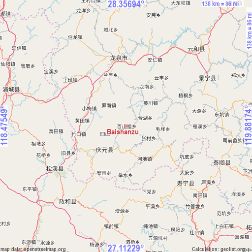
Baishanzu GPS coordinates[2]
27° 44' 11.004" North, 119° 10' 42.996" East
| Map corner | latitude | longitude |
|---|---|---|
| Upper-left | 28.35694°, | 118.47549° |
| Center: | 27.73639°, | 119.17861° |
| Lower-right: | 27.11229°, | 119.88174° |
| Map W x H: | 138.4×138.4 km | = 86×86mi |
| max Lat: | 53.31946° ⇑75.5% North |
| Baishanzu: | 27.73639° |
| min Lat: | ⇓24.5% South 18.22056° |
| min Long | Baishanzu | max Long |
| 75.07348° | 119.17861° | 134.28917° |
| W 77%⇐ | ⇒23% E |
Elevation
Elevation of Baishanzu is 1258 m = 4127 ft, and this is 773.2 m = 2537 ft above average elevation for this country.
| Max E: |
5622 m = 18445 ft | 11.1% |
| Baishanzu | 1258 m 4127 ft | |
| Avg. | 484.8 m = 1591 ft | |
Min E: |
-3 m = -10 ft | 88.9% |
See also: China elevation on elevation.city.
Geographical zone
Baishanzu is located in North temperate zone (between Tropic of Cancer and the Arctic Circle). Distance of this Northern Tropic circle is 478.1 km =297.1 mi to South.| Distance of | km | miles | from Baishanzu |
|---|---|---|---|
| North Pole | 6923.1 | 4301.8 | to North |
| Arctic Circle | 4317.2 | 2682.6 | to North |
| Tropic Cancer | 478.1 | 297.1 | to South |
| Equator | 3084 | 1916.3 | to South |


Nearby cities:
15 places around Baishanzu: (largest is in red/bold)
• Hedi
20.3 km =12.6 mi,  150°
150°
• Hehu
11.5 km =7.1 mi,  64°
64°
• Lingtou
21.5 km =13.4 mi,  161°
161°
• Maoyang
20.2 km =12.6 mi,  93°
93°
• Pingnan
15.1 km =9.4 mi,  321°
321°
• Qiulu
16.5 km =10.3 mi, 93°
• Sanxi
12.3 km =7.6 mi,  248°
248°
• Sishan
12.4 km =7.7 mi, 250°
• Songyuan
17.3 km =10.7 mi,  222°
222°
• Wudabao
14.3 km =8.9 mi,  183°
183°
• Xianliang
10.4 km =6.5 mi, 154°
• Xiaomei
22.6 km =14 mi,  296°
296°
• Yingchuan
18.7 km =11.6 mi,  46°
46°
• Zhangcun
13.9 km =8.6 mi,  117°
117°
• Zuoxi
23 km =14.3 mi, 120°
Sources, notices
• [Note1] Compared only with cities in China existing in our database
• [Src1] Map data: © OpenStreetMap contributors (CC-BY-SA)
• [Src2] Other city data from geonames.org with taken over terms of usage.
• [Src3] Geographical zone / Annual Mean Temperature by Robert A. Rohde @ Wikipedia
