Yingchuan geodata
Yingchuan (Zhejiang) is a seat of a fourth-order administrative division; located in China in Asia/Shanghai (GMT+8) time zone. In our database, there are 1268 cities with bigger population. Compared to other cities in China, 74.9% of cities are located further ↑North; 77.7% of cities are located further ←West and 72.7% of cities have lower elevation than Yingchuan. Note1


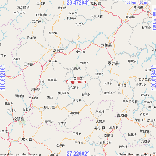
Yingchuan GPS coordinates[2]
27° 51' 11.016" North, 119° 18' 55.008" East
| Map corner | latitude | longitude |
|---|---|---|
| Upper-left | 28.47294°, | 118.61216° |
| Center: | 27.85306°, | 119.31528° |
| Lower-right: | 27.22962°, | 120.01841° |
| Map W x H: | 138.2×138.2 km | = 85.9×85.9mi |
| max Lat: | 53.31946° ⇑74.9% North |
| Yingchuan: | 27.85306° |
| min Lat: | ⇓25.1% South 18.22056° |
| min Long | Yingchuan | max Long |
| 75.07348° | 119.31528° | 134.28917° |
| W 77.7%⇐ | ⇒22.3% E |
Elevation
Elevation of Yingchuan is 467 m = 1532 ft, and this is 17.8 m = 58 ft below average elevation for this country.
| Max E: |
5622 m = 18445 ft | 27.3% |
| Avg. | 484.8 m = 1591 ft | |
| Yingchuan | 467 m = 1532 ft | |
Min E: |
-3 m = -10 ft | 72.7% |
See also: China elevation on elevation.city.
Geographical zone
Yingchuan is located in North temperate zone (between Tropic of Cancer and the Arctic Circle). Distance of this Northern Tropic circle is 491.1 km =305.2 mi to South.| Distance of | km | miles | from Yingchuan |
|---|---|---|---|
| North Pole | 6910.1 | 4293.7 | to North |
| Arctic Circle | 4304.2 | 2674.5 | to North |
| Tropic Cancer | 491.1 | 305.2 | to South |
| Equator | 3097 | 1924.4 | to South |


Nearby cities:
15 places around Yingchuan: (largest is in red/bold)
• Anren
23.3 km =14.5 mi,  5°
5°
• Baishanzu
18.7 km =11.6 mi,  226°
226°
• Biaoxi
18 km =11.2 mi,  90°
90°
• Dadi
17.2 km =10.7 mi,  124°
124°
• Geshan
5.3 km =3.3 mi,  37°
37°
• Hehu
8.6 km =5.3 mi,  201°
201°
• Longnan
9.3 km =5.8 mi,  346°
346°
• Luci
9 km =5.6 mi,  72°
72°
• Maoyang
15.8 km =9.8 mi,  155°
155°
• Pingnan
22.8 km =14.2 mi,  267°
267°
• Qiulu
14.4 km =8.9 mi,  167°
167°
• Shawan
14.7 km =9.1 mi, 89°
• Wutong
19.6 km =12.2 mi,  77°
77°
• Yunfeng
15 km =9.3 mi,  23°
23°
• Zhangcun
19.5 km =12.1 mi,  183°
183°
Sources, notices
• [Note1] Compared only with cities in China existing in our database
• [Src1] Map data: © OpenStreetMap contributors (CC-BY-SA)
• [Src2] Other city data from geonames.org with taken over terms of usage.
• [Src3] Geographical zone / Annual Mean Temperature by Robert A. Rohde @ Wikipedia
