Baisha geodata
Baisha (Hubei) is a seat of a fourth-order administrative division; located in China in Asia/Shanghai (GMT+8) time zone. In our database, there are 1268 cities with bigger population. Compared to other cities in China, 55.8% of cities are located further ↓South; 52% of cities are located further →East and 74.1% of cities have higher elevation than Baisha. Note1


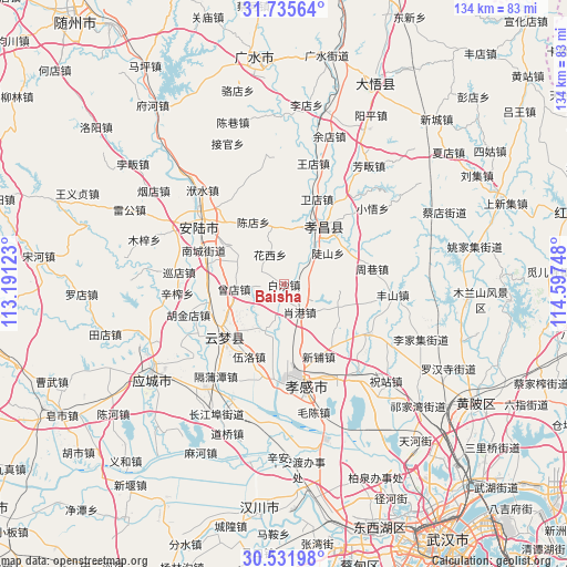
Baisha GPS coordinates[2]
31° 8' 8.592" North, 113° 53' 39.66" East
| Map corner | latitude | longitude |
|---|---|---|
| Upper-left | 31.73564°, | 113.19123° |
| Center: | 31.13572°, | 113.89435° |
| Lower-right: | 30.53198°, | 114.59748° |
| Map W x H: | 133.8×133.8 km | = 83.1×83.1mi |
| max Lat: | 53.31946° ⇑44.2% North |
| Baisha: | 31.13572° |
| min Lat: | ⇓55.8% South 18.22056° |
| min Long | Baisha | max Long |
| 75.07348° | 113.89435° | 134.28917° |
| W 48%⇐ | ⇒52% E |
Elevation
Elevation of Baisha is 39 m = 128 ft, and this is 445.8 m = 1463 ft below average elevation for this country.
| Max E: |
5622 m = 18445 ft | 74.1% |
| Avg. | 484.8 m = 1591 ft | |
| Baisha | 39 m = 128 ft | |
Min E: |
-3 m = -10 ft | 25.9% |
See also: China elevation on elevation.city.
Geographical zone
Baisha is located in North temperate zone (between Tropic of Cancer and the Arctic Circle). Distance of this Northern Tropic circle is 856 km =531.9 mi to South.| Distance of | km | miles | from Baisha |
|---|---|---|---|
| North Pole | 6545.1 | 4066.9 | to North |
| Arctic Circle | 3939.2 | 2447.7 | to North |
| Tropic Cancer | 856 | 531.9 | to South |
| Equator | 3462 | 2151.2 | to South |


Nearby cities:
15 places around Baisha: (largest is in red/bold)
• Chendian
16.4 km =10.2 mi,  333°
333°
• Daodian
16.9 km =10.5 mi,  288°
288°
• Dougang
11.4 km =7.1 mi,  201°
201°
• Doushan
12.7 km =7.9 mi,  54°
54°
• Huaxi
7.8 km =4.8 mi, 334°
• Jidian
16.9 km =10.5 mi,  2°
2°
• Lidian
15.8 km =9.8 mi,  304°
304°
• Wupu
13.9 km =8.6 mi,  219°
219°
• Xiaogang
7.5 km =4.7 mi,  150°
150°
• Xihe
17.9 km =11.1 mi,  142°
142°
• Xinpu
18.9 km =11.7 mi, 154°
• Yitang
18.6 km =11.6 mi,  256°
256°
• Yunmeng Chengguanzhen
14.7 km =9.1 mi,  236°
236°
• Zengdian
11.9 km =7.4 mi, 264°
• Zougang
14 km =8.7 mi,  113°
113°
Sources, notices
• [Note1] Compared only with cities in China existing in our database
• [Src1] Map data: © OpenStreetMap contributors (CC-BY-SA)
• [Src2] Other city data from geonames.org with taken over terms of usage.
• [Src3] Geographical zone / Annual Mean Temperature by Robert A. Rohde @ Wikipedia
