Yunmeng Chengguanzhen geodata
Yunmeng Chengguanzhen (Hubei) is a seat of a third-order administrative division; located in China in Asia/Shanghai (GMT+8) time zone. With population of 64,390 people, there are 676 cities with bigger population in this country. Compared to other cities in China, 55.3% of cities are located further ↓South; 52.7% of cities are located further →East and 72.7% of cities have higher elevation than Yunmeng Chengguanzhen. Note1


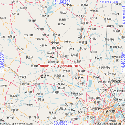
Yunmeng Chengguanzhen GPS coordinates[2]
31° 3' 45.036" North, 113° 45' 55.62" East
| Map corner | latitude | longitude |
|---|---|---|
| Upper-left | 31.6629°, | 113.06233° |
| Center: | 31.06251°, | 113.76545° |
| Lower-right: | 30.45831°, | 114.46858° |
| Map W x H: | 133.9×133.9 km | = 83.2×83.2mi |
| max Lat: | 53.31946° ⇑44.7% North |
| Yunmeng Chengguanzhen: | 31.06251° |
| min Lat: | ⇓55.3% South 18.22056° |
| min Long | Yunmeng Chenggu | max Long |
| 75.07348° | 113.76545° | 134.28917° |
| W 47.3%⇐ | ⇒52.7% E |
Elevation
Elevation of Yunmeng Chengguanzhen is 43 m = 141 ft, and this is 441.8 m = 1449 ft below average elevation for this country.
| Max E: |
5622 m = 18445 ft | 72.7% |
| Avg. | 484.8 m = 1591 ft | |
| Yunmeng Chengguanzhen | 43 m = 141 ft | |
Min E: |
-3 m = -10 ft | 27.3% |
See also: Yunmeng Chengguanzhen elevation on elevation.city.
Geographical zone
Yunmeng Chengguanzhen is located in North temperate zone (between Tropic of Cancer and the Arctic Circle). Distance of this Northern Tropic circle is 847.9 km =526.9 mi to South.| Distance of | km | miles | from Yunmeng Chengguanzhen |
|---|---|---|---|
| North Pole | 6553.2 | 4072 | to North |
| Arctic Circle | 3947.3 | 2452.7 | to North |
| Tropic Cancer | 847.9 | 526.9 | to South |
| Equator | 3453.8 | 2146.1 | to South |


Nearby cities:
15 places around Yunmeng Chengguanzhen: (largest is in red/bold)
• Baisha
14.7 km =9.1 mi,  56°
56°
• Daodian
14.1 km =8.8 mi,  344°
344°
• Dougang
8.5 km =5.3 mi,  106°
106°
• Geputan
14.1 km =8.8 mi,  195°
195°
• Hujindian
10.3 km =6.4 mi,  276°
276°
• Lidian
17.1 km =10.6 mi,  357°
357°
• Qingminghe
7.9 km =4.9 mi,  247°
247°
• Shahe
15.2 km =9.4 mi,  158°
158°
• Wuluo
9.7 km =6 mi, 156°
• Wupu
4.2 km =2.6 mi,  127°
127°
• Xiaogang
16.1 km =10 mi,  84°
84°
• Xinzha
14.3 km =8.9 mi,  294°
294°
• Xundian
16.7 km =10.4 mi,  311°
311°
• Yitang
6.9 km =4.3 mi,  302°
302°
• Zengdian
7.1 km =4.4 mi,  3°
3°
Sources, notices
• [Note1] Compared only with cities in China existing in our database
• [Src1] Map data: © OpenStreetMap contributors (CC-BY-SA)
• [Src2] Other city data from geonames.org with taken over terms of usage.
• [Src3] Geographical zone / Annual Mean Temperature by Robert A. Rohde @ Wikipedia
