Daodian geodata
Daodian (Hubei) is a seat of a fourth-order administrative division; located in China in Asia/Shanghai (GMT+8) time zone. In our database, there are 1268 cities with bigger population. Compared to other cities in China, 56.1% of cities are located further ↓South; 52.9% of cities are located further →East and 70% of cities have higher elevation than Daodian. Note1


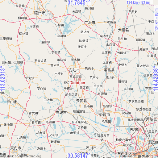
Daodian GPS coordinates[2]
31° 11' 5.64" North, 113° 43' 34.5" East
| Map corner | latitude | longitude |
|---|---|---|
| Upper-left | 31.78451°, | 113.02313° |
| Center: | 31.1849°, | 113.72625° |
| Lower-right: | 30.58147°, | 114.42938° |
| Map W x H: | 133.8×133.8 km | = 83.1×83.1mi |
| max Lat: | 53.31946° ⇑43.9% North |
| Daodian: | 31.1849° |
| min Lat: | ⇓56.1% South 18.22056° |
| min Long | Daodian | max Long |
| 75.07348° | 113.72625° | 134.28917° |
| W 47.1%⇐ | ⇒52.9% E |
Elevation
Elevation of Daodian is 52 m = 171 ft, and this is 432.8 m = 1420 ft below average elevation for this country.
| Max E: |
5622 m = 18445 ft | 70% |
| Avg. | 484.8 m = 1591 ft | |
| Daodian | 52 m = 171 ft | |
Min E: |
-3 m = -10 ft | 30% |
See also: China elevation on elevation.city.
Geographical zone
Daodian is located in North temperate zone (between Tropic of Cancer and the Arctic Circle). Distance of this Northern Tropic circle is 861.5 km =535.3 mi to South.| Distance of | km | miles | from Daodian |
|---|---|---|---|
| North Pole | 6539.6 | 4063.5 | to North |
| Arctic Circle | 3933.7 | 2444.3 | to North |
| Tropic Cancer | 861.5 | 535.3 | to South |
| Equator | 3467.4 | 2154.5 | to South |


Nearby cities:
15 places around Daodian: (largest is in red/bold)
• Anlu
9.3 km =5.8 mi,  330°
330°
• Baisha
16.9 km =10.5 mi,  108°
108°
• Chendian
12.7 km =7.9 mi,  43°
43°
• Huaxi
12.8 km =8 mi,  82°
82°
• Hujindian
14.1 km =8.8 mi,  207°
207°
• Lidian
4.6 km =2.9 mi, 40°
• Nancheng
3.8 km =2.4 mi,  312°
312°
• Qingminghe
17 km =10.6 mi,  191°
191°
• Tangdi
14.6 km =9.1 mi,  294°
294°
• Xinzha
11.9 km =7.4 mi,  230°
230°
• Xundian
9.2 km =5.7 mi,  253°
253°
• Yanghe
17 km =10.6 mi, 234°
• Yitang
10.1 km =6.3 mi, 191°
• Yunmeng Chengguanzhen
14.1 km =8.8 mi,  164°
164°
• Zengdian
7.8 km =4.8 mi,  147°
147°
Sources, notices
• [Note1] Compared only with cities in China existing in our database
• [Src1] Map data: © OpenStreetMap contributors (CC-BY-SA)
• [Src2] Other city data from geonames.org with taken over terms of usage.
• [Src3] Geographical zone / Annual Mean Temperature by Robert A. Rohde @ Wikipedia
