Baima geodata
Baima (Jiangsu) is a seat of a fourth-order administrative division; located in China in Asia/Shanghai (GMT+8) time zone. In our database, there are 1268 cities with bigger population. Compared to other cities in China, 58.9% of cities are located further ↓South; 76.9% of cities are located further ←West and 76.7% of cities have higher elevation than Baima. Note1


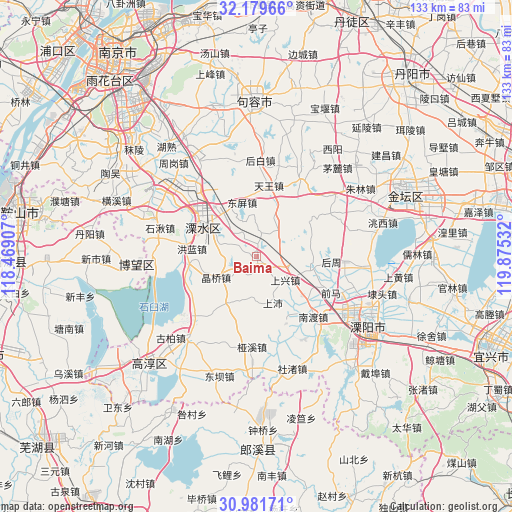
Baima GPS coordinates[2]
31° 34' 57.396" North, 119° 10' 19.884" East
| Map corner | latitude | longitude |
|---|---|---|
| Upper-left | 32.17966°, | 118.46907° |
| Center: | 31.58261°, | 119.17219° |
| Lower-right: | 30.98171°, | 119.87532° |
| Map W x H: | 133.2×133.2 km | = 82.8×82.8mi |
| max Lat: | 53.31946° ⇑41.1% North |
| Baima: | 31.58261° |
| min Lat: | ⇓58.9% South 18.22056° |
| min Long | Baima | max Long |
| 75.07348° | 119.17219° | 134.28917° |
| W 76.9%⇐ | ⇒23.1% E |
Elevation
Elevation of Baima is 33 m = 108 ft, and this is 451.8 m = 1482 ft below average elevation for this country.
| Max E: |
5622 m = 18445 ft | 76.7% |
| Avg. | 484.8 m = 1591 ft | |
| Baima | 33 m = 108 ft | |
Min E: |
-3 m = -10 ft | 23.3% |
See also: China elevation on elevation.city.
Geographical zone
Baima is located in North temperate zone (between Tropic of Cancer and the Arctic Circle). Distance of this Northern Tropic circle is 905.7 km =562.8 mi to South.| Distance of | km | miles | from Baima |
|---|---|---|---|
| North Pole | 6495.4 | 4036.1 | to North |
| Arctic Circle | 3889.5 | 2416.8 | to North |
| Tropic Cancer | 905.7 | 562.8 | to South |
| Equator | 3511.7 | 2182.1 | to South |


Nearby cities:
15 places around Baima: (largest is in red/bold)
• Changqiao
10.1 km =6.3 mi,  240°
240°
• Honglan
18.4 km =11.4 mi,  278°
278°
• Houbai
25 km =15.5 mi,  1°
1°
• Jingqiao
11.9 km =7.4 mi, 242°
• Nandu
21.6 km =13.4 mi,  136°
136°
• Shangpei
12.8 km =8 mi,  160°
160°
• Shangxing
9.4 km =5.8 mi,  129°
129°
• Shangxing
13.6 km =8.5 mi, 127°
• Shuiyang
15.7 km =9.8 mi,  303°
303°
• Tianwang
18.4 km =11.4 mi,  9°
9°
• Xuebu
24.1 km =15 mi,  51°
51°
• Yaxi
23.7 km =14.7 mi,  182°
182°
• Yongyang
16 km =9.9 mi, 301°
• Zhuze
14.6 km =9.1 mi,  99°
99°
• Zhuze
18.1 km =11.2 mi, 98°
Sources, notices
• [Note1] Compared only with cities in China existing in our database
• [Src1] Map data: © OpenStreetMap contributors (CC-BY-SA)
• [Src2] Other city data from geonames.org with taken over terms of usage.
• [Src3] Geographical zone / Annual Mean Temperature by Robert A. Rohde @ Wikipedia
