Honglan geodata
Honglan (Jiangsu) is a seat of a fourth-order administrative division; located in China in Asia/Shanghai (GMT+8) time zone. In our database, there are 1268 cities with bigger population. Compared to other cities in China, 59% of cities are located further ↓South; 75.9% of cities are located further ←West and 86.9% of cities have higher elevation than Honglan. Note1


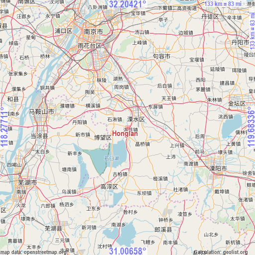
Honglan GPS coordinates[2]
31° 36' 26.352" North, 118° 58' 48.828" East
| Map corner | latitude | longitude |
|---|---|---|
| Upper-left | 32.20421°, | 118.27711° |
| Center: | 31.60732°, | 118.98023° |
| Lower-right: | 31.00658°, | 119.68336° |
| Map W x H: | 133.2×133.2 km | = 82.8×82.8mi |
| max Lat: | 53.31946° ⇑41% North |
| Honglan: | 31.60732° |
| min Lat: | ⇓59% South 18.22056° |
| min Long | Honglan | max Long |
| 75.07348° | 118.98023° | 134.28917° |
| W 75.9%⇐ | ⇒24.1% E |
Elevation
Elevation of Honglan is 13 m = 43 ft, and this is 471.8 m = 1548 ft below average elevation for this country.
| Max E: |
5622 m = 18445 ft | 86.9% |
| Avg. | 484.8 m = 1591 ft | |
| Honglan | 13 m = 43 ft | |
Min E: |
-3 m = -10 ft | 13.1% |
See also: China elevation on elevation.city.
Geographical zone
Honglan is located in North temperate zone (between Tropic of Cancer and the Arctic Circle). Distance of this Northern Tropic circle is 908.5 km =564.5 mi to South.| Distance of | km | miles | from Honglan |
|---|---|---|---|
| North Pole | 6492.7 | 4034.4 | to North |
| Arctic Circle | 3886.8 | 2415.1 | to North |
| Tropic Cancer | 908.5 | 564.5 | to South |
| Equator | 3514.4 | 2183.7 | to South |


Nearby cities:
15 places around Honglan: (largest is in red/bold)
• Baima
18.4 km =11.4 mi,  98°
98°
• Bowang
14.3 km =8.9 mi,  250°
250°
• Changqiao
12.2 km =7.6 mi,  129°
129°
• Danyang
25.2 km =15.7 mi,  275°
275°
• Hefeng
24 km =14.9 mi,  175°
175°
• Hengxi
23.6 km =14.7 mi,  301°
301°
• Jingqiao
11.2 km =7 mi,  136°
136°
• Lukou
21 km =13 mi,  329°
329°
• Qiqiao
24.4 km =15.2 mi, 178°
• Shiqiu
8.2 km =5.1 mi, 304°
• Shuiyang
7.9 km =4.9 mi,  40°
40°
• Xinshi
23.7 km =14.7 mi,  262°
262°
• Yongyang
7.2 km =4.5 mi, 38°
• Zhetang
17.6 km =10.9 mi,  339°
339°
• Zhougang
21.2 km =13.2 mi,  355°
355°
Sources, notices
• [Note1] Compared only with cities in China existing in our database
• [Src1] Map data: © OpenStreetMap contributors (CC-BY-SA)
• [Src2] Other city data from geonames.org with taken over terms of usage.
• [Src3] Geographical zone / Annual Mean Temperature by Robert A. Rohde @ Wikipedia
