Yongyang geodata
Yongyang (Jiangsu) is a seat of a third-order administrative division; located in China in Asia/Shanghai (GMT+8) time zone. In our database, there are 1268 cities with bigger population. Compared to other cities in China, 59.3% of cities are located further ↓South; 76.2% of cities are located further ←West and 81.2% of cities have higher elevation than Yongyang. Note1


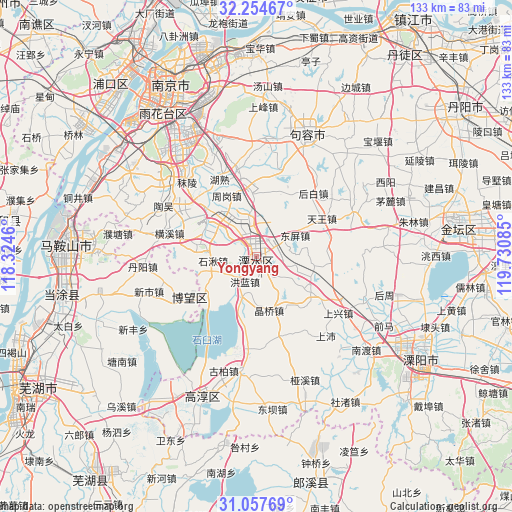
Yongyang GPS coordinates[2]
31° 39' 29.196" North, 119° 1' 39.792" East
| Map corner | latitude | longitude |
|---|---|---|
| Upper-left | 32.25467°, | 118.3246° |
| Center: | 31.65811°, | 119.02772° |
| Lower-right: | 31.05769°, | 119.73085° |
| Map W x H: | 133.1×133.1 km | = 82.7×82.7mi |
| max Lat: | 53.31946° ⇑40.7% North |
| Yongyang: | 31.65811° |
| min Lat: | ⇓59.3% South 18.22056° |
| min Long | Yongyang | max Long |
| 75.07348° | 119.02772° | 134.28917° |
| W 76.2%⇐ | ⇒23.8% E |
Elevation
Elevation of Yongyang is 24 m = 79 ft, and this is 460.8 m = 1512 ft below average elevation for this country.
| Max E: |
5622 m = 18445 ft | 81.2% |
| Avg. | 484.8 m = 1591 ft | |
| Yongyang | 24 m = 79 ft | |
Min E: |
-3 m = -10 ft | 18.8% |
See also: China elevation on elevation.city.
Geographical zone
Yongyang is located in North temperate zone (between Tropic of Cancer and the Arctic Circle). Distance of this Northern Tropic circle is 914.1 km =568 mi to South.| Distance of | km | miles | from Yongyang |
|---|---|---|---|
| North Pole | 6487 | 4030.8 | to North |
| Arctic Circle | 3881.1 | 2411.6 | to North |
| Tropic Cancer | 914.1 | 568 | to South |
| Equator | 3520.1 | 2187.3 | to South |


Nearby cities:
15 places around Yongyang: (largest is in red/bold)
• Baima
16 km =9.9 mi,  121°
121°
• Bowang
20.8 km =12.9 mi,  239°
239°
• Changqiao
14.2 km =8.8 mi,  159°
159°
• Hengxi
25.5 km =15.8 mi,  284°
284°
• Honglan
7.2 km =4.5 mi,  218°
218°
• Houbai
21.9 km =13.6 mi,  40°
40°
• Jingqiao
14.2 km =8.8 mi,  167°
167°
• Lukou
19.6 km =12.2 mi,  309°
309°
• Shangpei
27.2 km =16.9 mi,  138°
138°
• Shangxing
25.4 km =15.8 mi, 124°
• Shiqiu
11.3 km =7 mi,  265°
265°
• Shuiyang
0.7 km =0.4 mi,  58°
58°
• Tianwang
19.2 km =11.9 mi, 59°
• Zhetang
15.2 km =9.4 mi,  315°
315°
• Zhougang
16.7 km =10.4 mi,  337°
337°
Sources, notices
• [Note1] Compared only with cities in China existing in our database
• [Src1] Map data: © OpenStreetMap contributors (CC-BY-SA)
• [Src2] Other city data from geonames.org with taken over terms of usage.
• [Src3] Geographical zone / Annual Mean Temperature by Robert A. Rohde @ Wikipedia
