Dangshan geodata
Dangshan (Zhejiang) is a seat of a fourth-order administrative division; located in China in Asia/Shanghai (GMT+8) time zone. In our database, there are 1268 cities with bigger population. Compared to other cities in China, 52.4% of cities are located further ↑North; 85.2% of cities are located further ←West and 84.9% of cities have higher elevation than Dangshan. Note1


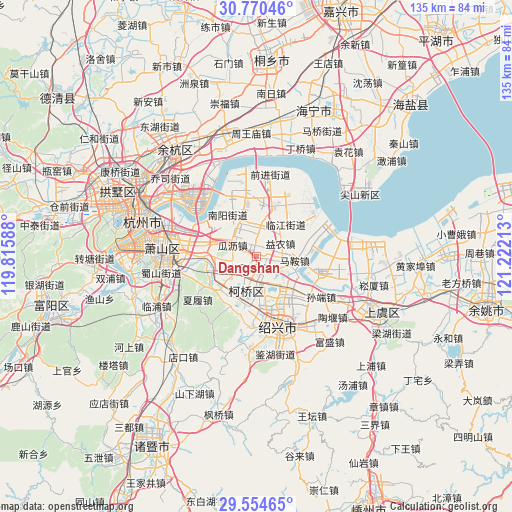
Dangshan GPS coordinates[2]
30° 9' 51.948" North, 120° 31' 8.4" East
| Map corner | latitude | longitude |
|---|---|---|
| Upper-left | 30.77046°, | 119.81588° |
| Center: | 30.16443°, | 120.519° |
| Lower-right: | 29.55465°, | 121.22213° |
| Map W x H: | 135.2×135.2 km | = 84×84mi |
| max Lat: | 53.31946° ⇑52.4% North |
| Dangshan: | 30.16443° |
| min Lat: | ⇓47.6% South 18.22056° |
| min Long | Dangshan | max Long |
| 75.07348° | 120.519° | 134.28917° |
| W 85.2%⇐ | ⇒14.8% E |
Elevation
Elevation of Dangshan is 16 m = 52 ft, and this is 468.8 m = 1538 ft below average elevation for this country.
| Max E: |
5622 m = 18445 ft | 84.9% |
| Avg. | 484.8 m = 1591 ft | |
| Dangshan | 16 m = 52 ft | |
Min E: |
-3 m = -10 ft | 15.1% |
See also: China elevation on elevation.city.
Geographical zone
Dangshan is located in North temperate zone (between Tropic of Cancer and the Arctic Circle). Distance of this Northern Tropic circle is 748.1 km =464.8 mi to South.| Distance of | km | miles | from Dangshan |
|---|---|---|---|
| North Pole | 6653.1 | 4134 | to North |
| Arctic Circle | 4047.2 | 2514.8 | to North |
| Tropic Cancer | 748.1 | 464.8 | to South |
| Equator | 3354 | 2084.1 | to South |


Nearby cities:
15 places around Dangshan: (largest is in red/bold)
• Anchang
4.2 km =2.6 mi,  231°
231°
• Dangwan
7.6 km =4.7 mi,  18°
18°
• Dongpu
12.1 km =7.5 mi,  174°
174°
• Doumen
10.3 km =6.4 mi,  136°
136°
• Guali
6.8 km =4.2 mi,  291°
291°
• Huashe
6.7 km =4.2 mi,  211°
211°
• Jingjiang
9.4 km =5.8 mi,  324°
324°
• Kanshan
11.2 km =7 mi, 286°
• Ma’an
6.3 km =3.9 mi,  107°
107°
• Qianqing
11.8 km =7.3 mi,  248°
248°
• Qixian
5 km =3.1 mi,  159°
159°
• Xinwan
12.9 km =8 mi,  8°
8°
• Yaqian
11.1 km =6.9 mi,  268°
268°
• Yinong
7.4 km =4.6 mi,  60°
60°
• Yipeng
11.2 km =7 mi,  344°
344°
Sources, notices
• [Note1] Compared only with cities in China existing in our database
• [Src1] Map data: © OpenStreetMap contributors (CC-BY-SA)
• [Src2] Other city data from geonames.org with taken over terms of usage.
• [Src3] Geographical zone / Annual Mean Temperature by Robert A. Rohde @ Wikipedia
