Yipeng geodata
Yipeng (Zhejiang) is a seat of a fourth-order administrative division; located in China in Asia/Shanghai (GMT+8) time zone. In our database, there are 1268 cities with bigger population. Compared to other cities in China, 51.6% of cities are located further ↑North; 85% of cities are located further ←West and 88.7% of cities have higher elevation than Yipeng. Note1


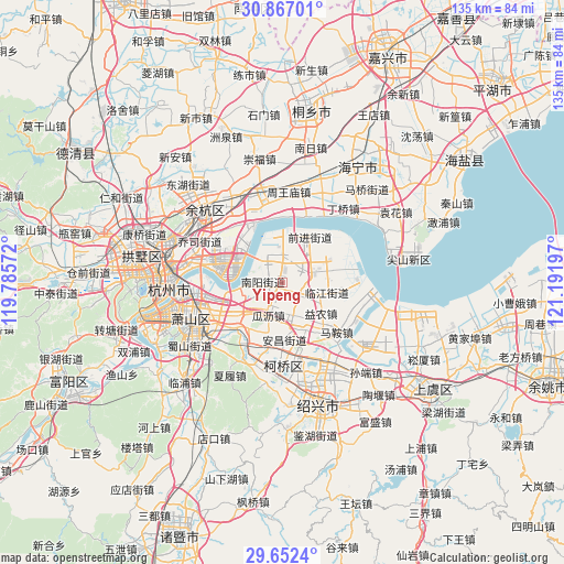
Yipeng GPS coordinates[2]
30° 15' 41.688" North, 120° 29' 19.824" East
| Map corner | latitude | longitude |
|---|---|---|
| Upper-left | 30.86701°, | 119.78572° |
| Center: | 30.26158°, | 120.48884° |
| Lower-right: | 29.6524°, | 121.19197° |
| Map W x H: | 135.1×135.1 km | = 83.9×83.9mi |
| max Lat: | 53.31946° ⇑51.6% North |
| Yipeng: | 30.26158° |
| min Lat: | ⇓48.4% South 18.22056° |
| min Long | Yipeng | max Long |
| 75.07348° | 120.48884° | 134.28917° |
| W 85%⇐ | ⇒15% E |
Elevation
Elevation of Yipeng is 11 m = 36 ft, and this is 473.8 m = 1554 ft below average elevation for this country.
| Max E: |
5622 m = 18445 ft | 88.7% |
| Avg. | 484.8 m = 1591 ft | |
| Yipeng | 11 m = 36 ft | |
Min E: |
-3 m = -10 ft | 11.3% |
See also: China elevation on elevation.city.
Geographical zone
Yipeng is located in North temperate zone (between Tropic of Cancer and the Arctic Circle). Distance of this Northern Tropic circle is 758.9 km =471.6 mi to South.| Distance of | km | miles | from Yipeng |
|---|---|---|---|
| North Pole | 6642.3 | 4127.3 | to North |
| Arctic Circle | 4036.4 | 2508.1 | to North |
| Tropic Cancer | 758.9 | 471.6 | to South |
| Equator | 3364.8 | 2090.8 | to South |


Nearby cities:
15 places around Yipeng: (largest is in red/bold)
• Anchang
13.4 km =8.3 mi,  181°
181°
• Dangshan
11.2 km =7 mi,  164°
164°
• Dangwan
6.4 km =4 mi,  124°
124°
• Guali
9 km =5.6 mi,  202°
202°
• Hezhuang
5 km =3.1 mi,  328°
328°
• Huashe
16.6 km =10.3 mi, 182°
• Jingjiang
4 km =2.5 mi,  219°
219°
• Kanshan
10.9 km =6.8 mi,  226°
226°
• Ma’an
15.5 km =9.6 mi,  144°
144°
• Nanyang
4.4 km =2.7 mi,  271°
271°
• Qixian
16.1 km =10 mi, 163°
• Xinjie
16.9 km =10.5 mi,  242°
242°
• Xinwan
5.1 km =3.2 mi,  68°
68°
• Yaqian
13.8 km =8.6 mi, 216°
• Yinong
11.8 km =7.3 mi,  127°
127°
Sources, notices
• [Note1] Compared only with cities in China existing in our database
• [Src1] Map data: © OpenStreetMap contributors (CC-BY-SA)
• [Src2] Other city data from geonames.org with taken over terms of usage.
• [Src3] Geographical zone / Annual Mean Temperature by Robert A. Rohde @ Wikipedia
