Shuangchao geodata
Shuangchao (Zhejiang) is a seat of a fourth-order administrative division; located in China in Asia/Shanghai (GMT+8) time zone. In our database, there are 1268 cities with bigger population. Compared to other cities in China, 73% of cities are located further ↑North; 84.7% of cities are located further ←West and 86.9% of cities have higher elevation than Shuangchao. Note1


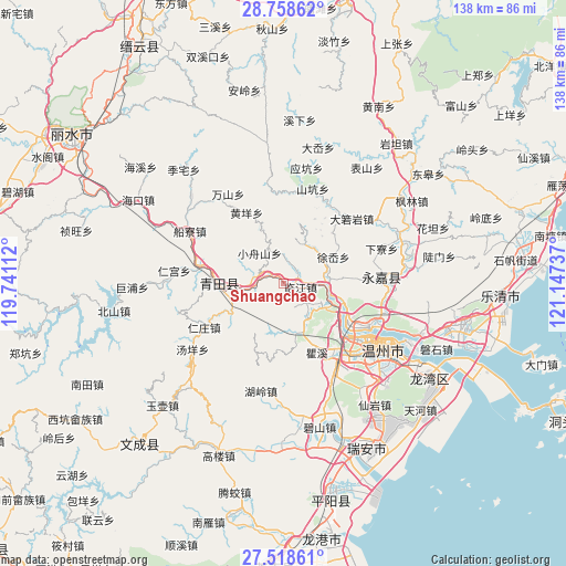
Shuangchao GPS coordinates[2]
28° 8' 25.476" North, 120° 26' 39.264" East
| Map corner | latitude | longitude |
|---|---|---|
| Upper-left | 28.75862°, | 119.74112° |
| Center: | 28.14041°, | 120.44424° |
| Lower-right: | 27.51861°, | 121.14737° |
| Map W x H: | 137.9×137.9 km | = 85.7×85.7mi |
| max Lat: | 53.31946° ⇑73% North |
| Shuangchao: | 28.14041° |
| min Lat: | ⇓27% South 18.22056° |
| min Long | Shuangchao | max Long |
| 75.07348° | 120.44424° | 134.28917° |
| W 84.7%⇐ | ⇒15.3% E |
Elevation
Elevation of Shuangchao is 13 m = 43 ft, and this is 471.8 m = 1548 ft below average elevation for this country.
| Max E: |
5622 m = 18445 ft | 86.9% |
| Avg. | 484.8 m = 1591 ft | |
| Shuangchao | 13 m = 43 ft | |
Min E: |
-3 m = -10 ft | 13.1% |
See also: China elevation on elevation.city.
Geographical zone
Shuangchao is located in North temperate zone (between Tropic of Cancer and the Arctic Circle). Distance of this Northern Tropic circle is 523 km =325 mi to South.| Distance of | km | miles | from Shuangchao |
|---|---|---|---|
| North Pole | 6878.1 | 4273.9 | to North |
| Arctic Circle | 4272.3 | 2654.7 | to North |
| Tropic Cancer | 523 | 325 | to South |
| Equator | 3128.9 | 1944.2 | to South |


Nearby cities:
15 places around Shuangchao: (largest is in red/bold)
• Fangshan
18.3 km =11.4 mi,  224°
224°
• Gui’ao
9.7 km =6 mi,  292°
292°
• Hecheng
15.3 km =9.5 mi,  269°
269°
• Kunyang
17.1 km =10.6 mi,  43°
43°
• Linjiang
4.3 km =2.7 mi,  100°
100°
• Ming’ao
17.5 km =10.9 mi,  25°
25°
• Qiaotou
4.4 km =2.7 mi, 40°
• Qiaoxia
11.4 km =7.1 mi,  73°
73°
• Shankou
14.7 km =9.1 mi,  238°
238°
• Tengqiao
9.6 km =6 mi,  145°
145°
• Wenxi
6.1 km =3.8 mi, 290°
• Wukeng
12 km =7.5 mi,  339°
339°
• Xiaozhoushan
9.4 km =5.8 mi,  321°
321°
• Xixi
11.2 km =7 mi, 43°
• Xu’ao
13.8 km =8.6 mi,  61°
61°
Sources, notices
• [Note1] Compared only with cities in China existing in our database
• [Src1] Map data: © OpenStreetMap contributors (CC-BY-SA)
• [Src2] Other city data from geonames.org with taken over terms of usage.
• [Src3] Geographical zone / Annual Mean Temperature by Robert A. Rohde @ Wikipedia
