Kunyang geodata
Kunyang (Zhejiang) is a seat of a fourth-order administrative division; located in China in Asia/Shanghai (GMT+8) time zone. In our database, there are 1268 cities with bigger population. Compared to other cities in China, 71.9% of cities are located further ↑North; 85.5% of cities are located further ←West and 52% of cities have lower elevation than Kunyang. Note1


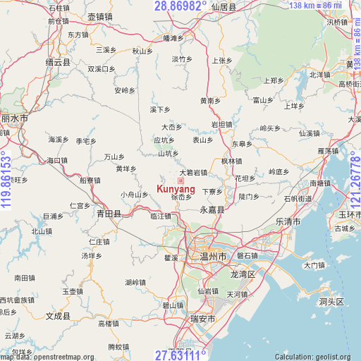
Kunyang GPS coordinates[2]
28° 15' 8.136" North, 120° 33' 52.74" East
| Map corner | latitude | longitude |
|---|---|---|
| Upper-left | 28.86982°, | 119.86153° |
| Center: | 28.25226°, | 120.56465° |
| Lower-right: | 27.63111°, | 121.26778° |
| Map W x H: | 137.7×137.7 km | = 85.6×85.6mi |
| max Lat: | 53.31946° ⇑71.9% North |
| Kunyang: | 28.25226° |
| min Lat: | ⇓28.1% South 18.22056° |
| min Long | Kunyang | max Long |
| 75.07348° | 120.56465° | 134.28917° |
| W 85.5%⇐ | ⇒14.5% E |
Elevation
Elevation of Kunyang is 181 m = 594 ft, and this is 303.8 m = 997 ft below average elevation for this country.
| Max E: |
5622 m = 18445 ft | 48% |
| Avg. | 484.8 m = 1591 ft | |
| Kunyang | 181 m = 594 ft | |
Min E: |
-3 m = -10 ft | 52% |
See also: China elevation on elevation.city.
Geographical zone
Kunyang is located in North temperate zone (between Tropic of Cancer and the Arctic Circle). Distance of this Northern Tropic circle is 535.4 km =332.7 mi to South.| Distance of | km | miles | from Kunyang |
|---|---|---|---|
| North Pole | 6865.7 | 4266.1 | to North |
| Arctic Circle | 4259.8 | 2646.9 | to North |
| Tropic Cancer | 535.4 | 332.7 | to South |
| Equator | 3141.4 | 1952 | to South |


Nearby cities:
15 places around Kunyang: (largest is in red/bold)
• Bilian
6.9 km =4.3 mi,  353°
353°
• Daruoyan
6 km =3.7 mi,  54°
54°
• Linjiang
15.2 km =9.4 mi,  209°
209°
• Ming’ao
5.3 km =3.3 mi,  308°
308°
• Qiaotou
12.7 km =7.9 mi,  224°
224°
• Qiaoxia
9.3 km =5.8 mi,  185°
185°
• Qukou
15.4 km =9.6 mi,  84°
84°
• Shangtang
16.2 km =10.1 mi,  131°
131°
• Shankeng
11.7 km =7.3 mi,  336°
336°
• Wukeng
16 km =9.9 mi,  265°
265°
• Xialiao
12.7 km =7.9 mi,  107°
107°
• Xixi
5.9 km =3.7 mi, 223°
• Xunzhai
13.4 km =8.3 mi,  322°
322°
• Xu’ao
5.9 km =3.7 mi,  176°
176°
• Yingkeng
16.9 km =10.5 mi, 338°
Sources, notices
• [Note1] Compared only with cities in China existing in our database
• [Src1] Map data: © OpenStreetMap contributors (CC-BY-SA)
• [Src2] Other city data from geonames.org with taken over terms of usage.
• [Src3] Geographical zone / Annual Mean Temperature by Robert A. Rohde @ Wikipedia
