Loufeng geodata
Loufeng (Jiangsu) is a seat of a fourth-order administrative division; located in China in Asia/Shanghai (GMT+8) time zone. In our database, there are 1268 cities with bigger population. Compared to other cities in China, 56.9% of cities are located further ↓South; 86% of cities are located further ←West and 95.9% of cities have higher elevation than Loufeng. Note1


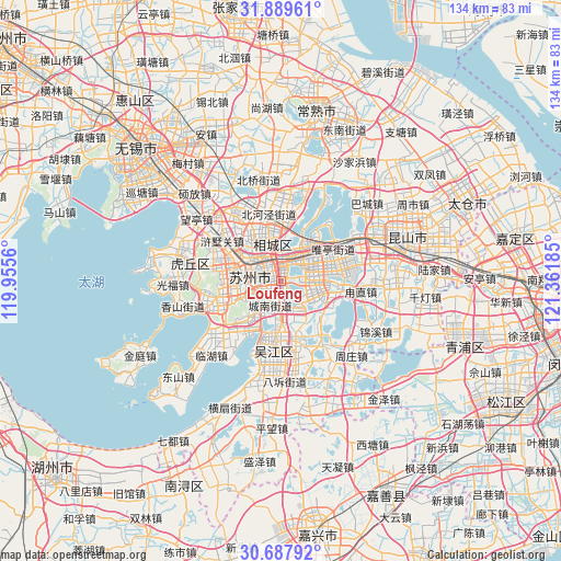
Loufeng GPS coordinates[2]
31° 17' 26.448" North, 120° 39' 31.392" East
| Map corner | latitude | longitude |
|---|---|---|
| Upper-left | 31.88961°, | 119.9556° |
| Center: | 31.29068°, | 120.65872° |
| Lower-right: | 30.68792°, | 121.36185° |
| Map W x H: | 133.6×133.6 km | = 83×83mi |
| max Lat: | 53.31946° ⇑43.1% North |
| Loufeng: | 31.29068° |
| min Lat: | ⇓56.9% South 18.22056° |
| min Long | Loufeng | max Long |
| 75.07348° | 120.65872° | 134.28917° |
| W 86%⇐ | ⇒14% E |
Elevation
Elevation of Loufeng is 6 m = 20 ft, and this is 478.8 m = 1571 ft below average elevation for this country.
| Max E: |
5622 m = 18445 ft | 95.9% |
| Avg. | 484.8 m = 1591 ft | |
| Loufeng | 6 m = 20 ft | |
Min E: |
-3 m = -10 ft | 4.1% |
See also: China elevation on elevation.city.
Geographical zone
Loufeng is located in North temperate zone (between Tropic of Cancer and the Arctic Circle). Distance of this Northern Tropic circle is 873.3 km =542.6 mi to South.| Distance of | km | miles | from Loufeng |
|---|---|---|---|
| North Pole | 6527.9 | 4056.2 | to North |
| Arctic Circle | 3922 | 2437 | to North |
| Tropic Cancer | 873.3 | 542.6 | to South |
| Equator | 3479.2 | 2161.9 | to South |


Nearby cities:
15 places around Loufeng: (largest is in red/bold)
• Baiyangwan
12.8 km =8 mi,  299°
299°
• Fengqiao
10.8 km =6.7 mi,  283°
283°
• Guoxiang
4.2 km =2.6 mi,  163°
163°
• Mudu
13.9 km =8.6 mi,  253°
253°
• Pingjianglu
3.8 km =2.4 mi,  314°
314°
• Shengpu
15.1 km =9.4 mi,  83°
83°
• Shilu
6.6 km =4.1 mi,  290°
290°
• Shishan
8.9 km =5.5 mi, 275°
• Shuangta
3.1 km =1.9 mi, 298°
• Songling
12.2 km =7.6 mi,  152°
152°
• Songlong
14.4 km =8.9 mi,  187°
187°
• Suzhou
6.2 km =3.9 mi, 283°
• Weiting
7.1 km =4.4 mi,  28°
28°
• Yuanhe
12.8 km =8 mi,  340°
340°
• Yuexi
10.9 km =6.8 mi,  220°
220°
Sources, notices
• [Note1] Compared only with cities in China existing in our database
• [Src1] Map data: © OpenStreetMap contributors (CC-BY-SA)
• [Src2] Other city data from geonames.org with taken over terms of usage.
• [Src3] Geographical zone / Annual Mean Temperature by Robert A. Rohde @ Wikipedia
