Shouqiao geodata
Shouqiao (Chongqing) is a seat of a fourth-order administrative division; located in China in Asia/Shanghai (GMT+8) time zone. In our database, there are 1268 cities with bigger population. Compared to other cities in China, 55.1% of cities are located further ↑North; 87.2% of cities are located further →East and 58.8% of cities have lower elevation than Shouqiao. Note1


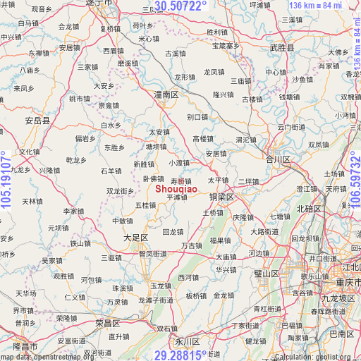
Shouqiao GPS coordinates[2]
29° 53' 58.38" North, 105° 53' 39.084" East
| Map corner | latitude | longitude |
|---|---|---|
| Upper-left | 30.50722°, | 105.19107° |
| Center: | 29.89955°, | 105.89419° |
| Lower-right: | 29.28815°, | 106.59732° |
| Map W x H: | 135.5×135.5 km | = 84.2×84.2mi |
| max Lat: | 53.31946° ⇑55.1% North |
| Shouqiao: | 29.89955° |
| min Lat: | ⇓44.9% South 18.22056° |
| min Long | Shouqiao | max Long |
| 75.07348° | 105.89419° | 134.28917° |
| W 12.8%⇐ | ⇒87.2% E |
Elevation
Elevation of Shouqiao is 245 m = 804 ft, and this is 239.8 m = 787 ft below average elevation for this country.
| Max E: |
5622 m = 18445 ft | 41.2% |
| Avg. | 484.8 m = 1591 ft | |
| Shouqiao | 245 m = 804 ft | |
Min E: |
-3 m = -10 ft | 58.8% |
See also: China elevation on elevation.city.
Geographical zone
Shouqiao is located in North temperate zone (between Tropic of Cancer and the Arctic Circle). Distance of this Northern Tropic circle is 718.6 km =446.5 mi to South.| Distance of | km | miles | from Shouqiao |
|---|---|---|---|
| North Pole | 6682.5 | 4152.3 | to North |
| Arctic Circle | 4076.7 | 2533.1 | to North |
| Tropic Cancer | 718.6 | 446.5 | to South |
| Equator | 3324.5 | 2065.7 | to South |


Nearby cities:
15 places around Shouqiao: (largest is in red/bold)
• Anju
16.7 km =10.4 mi,  52°
52°
• Bachuan
16.1 km =10 mi,  110°
110°
• Guoliang
15.1 km =9.4 mi,  169°
169°
• Lüfeng
8.9 km =5.5 mi,  121°
121°
• Pingtan
6.2 km =3.9 mi,  194°
194°
• Shaoyun
12.8 km =8 mi,  42°
42°
• Shuangshan
10.8 km =6.7 mi,  215°
215°
• Taiping
13.9 km =8.6 mi,  88°
88°
• Tangba
16 km =9.9 mi,  324°
324°
• Weixin
16.4 km =10.2 mi,  359°
359°
• Wofo
10.4 km =6.5 mi,  275°
275°
• Wugui
16.1 km =10 mi,  236°
236°
• Xiaodu
7 km =4.3 mi,  354°
354°
• Xiaolin
13.1 km =8.1 mi,  198°
198°
• Xinsheng
15.2 km =9.4 mi,  294°
294°
Sources, notices
• [Note1] Compared only with cities in China existing in our database
• [Src1] Map data: © OpenStreetMap contributors (CC-BY-SA)
• [Src2] Other city data from geonames.org with taken over terms of usage.
• [Src3] Geographical zone / Annual Mean Temperature by Robert A. Rohde @ Wikipedia
