Xinglong geodata
Xinglong (Gansu) is a seat of a fourth-order administrative division; located in China in Asia/Shanghai (GMT+8) time zone. In our database, there are 1268 cities with bigger population. Compared to other cities in China, 70.2% of cities are located further ↓South; 88.5% of cities are located further →East and 92.5% of cities have lower elevation than Xinglong. Note1


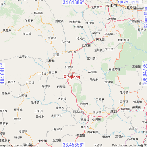
Xinglong GPS coordinates[2]
34° 2' 17.556" North, 105° 20' 39.192" East
| Map corner | latitude | longitude |
|---|---|---|
| Upper-left | 34.61886°, | 104.6411° |
| Center: | 34.03821°, | 105.34422° |
| Lower-right: | 33.45356°, | 106.04735° |
| Map W x H: | 129.6×129.6 km | = 80.5×80.5mi |
| max Lat: | 53.31946° ⇑29.8% North |
| Xinglong: | 34.03821° |
| min Lat: | ⇓70.2% South 18.22056° |
| min Long | Xinglong | max Long |
| 75.07348° | 105.34422° | 134.28917° |
| W 11.5%⇐ | ⇒88.5% E |
Elevation
Elevation of Xinglong is 1640 m = 5381 ft, and this is 1155.2 m = 3790 ft above average elevation for this country.
| Max E: |
5622 m = 18445 ft | 7.5% |
| Xinglong | 1640 m 5381 ft | |
| Avg. | 484.8 m = 1591 ft | |
Min E: |
-3 m = -10 ft | 92.5% |
See also: China elevation on elevation.city.
Geographical zone
Xinglong is located in North temperate zone (between Tropic of Cancer and the Arctic Circle). Distance of this Northern Tropic circle is 1178.8 km =732.5 mi to South.| Distance of | km | miles | from Xinglong |
|---|---|---|---|
| North Pole | 6222.4 | 3866.4 | to North |
| Arctic Circle | 3616.5 | 2247.2 | to North |
| Tropic Cancer | 1178.8 | 732.5 | to South |
| Equator | 3784.7 | 2351.7 | to South |


Nearby cities:
15 places around Xinglong: (largest is in red/bold)
• Hanyuan
5.7 km =3.5 mi,  237°
237°
• Heba
16.4 km =10.2 mi,  226°
226°
• Hekou
25.3 km =15.7 mi,  224°
224°
• Jiangkou
22.6 km =14 mi,  275°
275°
• Jiangxi
14 km =8.7 mi,  251°
251°
• Leiwang
18.5 km =11.5 mi,  274°
274°
• Longlin
27.6 km =17.1 mi, 247°
• Luhe
3.2 km =2 mi,  186°
186°
• Luoyu
24.3 km =15.1 mi,  205°
205°
• Mayuan
16.5 km =10.3 mi,  83°
83°
• Shaijing
14.7 km =9.1 mi,  114°
114°
• Shibao
7.3 km =4.5 mi,  324°
324°
• Shili
10.7 km =6.6 mi, 206°
• Suhe
11.6 km =7.2 mi, 283°
• Zhaowu
6.7 km =4.2 mi, 208°
Sources, notices
• [Note1] Compared only with cities in China existing in our database
• [Src1] Map data: © OpenStreetMap contributors (CC-BY-SA)
• [Src2] Other city data from geonames.org with taken over terms of usage.
• [Src3] Geographical zone / Annual Mean Temperature by Robert A. Rohde @ Wikipedia
