Zhaowu geodata
Zhaowu (Gansu) is a seat of a fourth-order administrative division; located in China in Asia/Shanghai (GMT+8) time zone. In our database, there are 1268 cities with bigger population. Compared to other cities in China, 70% of cities are located further ↓South; 88.6% of cities are located further →East and 92.4% of cities have lower elevation than Zhaowu. Note1


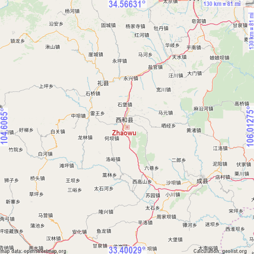
Zhaowu GPS coordinates[2]
33° 59' 7.08" North, 105° 18' 34.632" East
| Map corner | latitude | longitude |
|---|---|---|
| Upper-left | 34.56631°, | 104.6065° |
| Center: | 33.9853°, | 105.30962° |
| Lower-right: | 33.40029°, | 106.01275° |
| Map W x H: | 129.6×129.7 km | = 80.5×80.6mi |
| max Lat: | 53.31946° ⇑30% North |
| Zhaowu: | 33.9853° |
| min Lat: | ⇓70% South 18.22056° |
| min Long | Zhaowu | max Long |
| 75.07348° | 105.30962° | 134.28917° |
| W 11.4%⇐ | ⇒88.6% E |
Elevation
Elevation of Zhaowu is 1622 m = 5322 ft, and this is 1137.2 m = 3731 ft above average elevation for this country.
| Max E: |
5622 m = 18445 ft | 7.6% |
| Zhaowu | 1622 m 5322 ft | |
| Avg. | 484.8 m = 1591 ft | |
Min E: |
-3 m = -10 ft | 92.4% |
See also: China elevation on elevation.city.
Geographical zone
Zhaowu is located in North temperate zone (between Tropic of Cancer and the Arctic Circle). Distance of this Northern Tropic circle is 1172.9 km =728.8 mi to South.| Distance of | km | miles | from Zhaowu |
|---|---|---|---|
| North Pole | 6228.3 | 3870.1 | to North |
| Arctic Circle | 3622.4 | 2250.9 | to North |
| Tropic Cancer | 1172.9 | 728.8 | to South |
| Equator | 3778.8 | 2348 | to South |


Nearby cities:
15 places around Zhaowu: (largest is in red/bold)
• Hanyuan
3.3 km =2.1 mi,  330°
330°
• Heba
10.2 km =6.3 mi,  237°
237°
• Hekou
18.9 km =11.7 mi,  229°
229°
• Jiangkou
21 km =13 mi,  292°
292°
• Jiangxi
10.2 km =6.3 mi,  278°
278°
• Leiwang
16.9 km =10.5 mi,  295°
295°
• Luhe
3.9 km =2.4 mi,  46°
46°
• Luoyu
17.6 km =10.9 mi,  204°
204°
• Mayuan
21.1 km =13.1 mi,  68°
68°
• Shaijing
16.5 km =10.3 mi,  90°
90°
• Shibao
11.9 km =7.4 mi,  354°
354°
• Shili
4 km =2.5 mi, 203°
• Suhe
11.8 km =7.3 mi,  316°
316°
• Xiji
22.8 km =14.2 mi,  187°
187°
• Xinglong
6.7 km =4.2 mi,  28°
28°
Sources, notices
• [Note1] Compared only with cities in China existing in our database
• [Src1] Map data: © OpenStreetMap contributors (CC-BY-SA)
• [Src2] Other city data from geonames.org with taken over terms of usage.
• [Src3] Geographical zone / Annual Mean Temperature by Robert A. Rohde @ Wikipedia
