Donggaocun geodata
Donggaocun (Shanxi) is a seat of a fourth-order administrative division; located in China in Asia/Shanghai (GMT+8) time zone. In our database, there are 1268 cities with bigger population. Compared to other cities in China, 76.3% of cities are located further ↓South; 65.9% of cities are located further →East and 70.7% of cities have lower elevation than Donggaocun. Note1


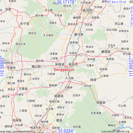
Donggaocun GPS coordinates[2]
35° 36' 7.668" North, 111° 17' 31.704" East
| Map corner | latitude | longitude |
|---|---|---|
| Upper-left | 36.17178°, | 110.58902° |
| Center: | 35.60213°, | 111.29214° |
| Lower-right: | 35.0284°, | 111.99527° |
| Map W x H: | 127.1×127.1 km | = 79×79mi |
| max Lat: | 53.31946° ⇑23.7% North |
| Donggaocun: | 35.60213° |
| min Lat: | ⇓76.3% South 18.22056° |
| min Long | Donggaocun | max Long |
| 75.07348° | 111.29214° | 134.28917° |
| W 34.1%⇐ | ⇒65.9% E |
Elevation
Elevation of Donggaocun is 425 m = 1394 ft, and this is 59.8 m = 196 ft below average elevation for this country.
| Max E: |
5622 m = 18445 ft | 29.3% |
| Avg. | 484.8 m = 1591 ft | |
| Donggaocun | 425 m = 1394 ft | |
Min E: |
-3 m = -10 ft | 70.7% |
See also: China elevation on elevation.city.
Geographical zone
Donggaocun is located in North temperate zone (between Tropic of Cancer and the Arctic Circle). Distance of this Northern Tropic circle is 1352.7 km =840.5 mi to South.| Distance of | km | miles | from Donggaocun |
|---|---|---|---|
| North Pole | 6048.5 | 3758.4 | to North |
| Arctic Circle | 3442.6 | 2139.1 | to North |
| Tropic Cancer | 1352.7 | 840.5 | to South |
| Equator | 3958.6 | 2459.8 | to South |


Nearby cities:
15 places around Donggaocun: (largest is in red/bold)
• Fengcheng
13.5 km =8.4 mi,  75°
75°
• Gaoxian
17.4 km =10.8 mi,  41°
41°
• Hengqiao
6.8 km =4.2 mi,  246°
246°
• Lechang
16.4 km =10.2 mi,  74°
74°
• Liyuan
11 km =6.8 mi,  165°
165°
• Longxing
6.7 km =4.2 mi,  280°
280°
• Sanquan
14.6 km =9.1 mi,  303°
303°
• Shangma
4.7 km =2.9 mi,  106°
106°
• Shangyuan
14.5 km =9 mi, 275°
• Wan’an
16.3 km =10.1 mi, 245°
• Xintian
6 km =3.7 mi, 77°
• Xuedian
16.9 km =10.5 mi,  209°
209°
• Yonggu
14.7 km =9.1 mi,  25°
25°
• Zhangcun
7.4 km =4.6 mi, 44°
• Zhaokang
13.8 km =8.6 mi,  342°
342°
Sources, notices
• [Note1] Compared only with cities in China existing in our database
• [Src1] Map data: © OpenStreetMap contributors (CC-BY-SA)
• [Src2] Other city data from geonames.org with taken over terms of usage.
• [Src3] Geographical zone / Annual Mean Temperature by Robert A. Rohde @ Wikipedia
