Xiachuan geodata
Xiachuan (Guangdong) is a seat of a fourth-order administrative division; located in China in Asia/Shanghai (GMT+8) time zone. In our database, there are 1268 cities with bigger population. Compared to other cities in China, 97.8% of cities are located further ↑North; 59.6% of cities are located further →East and 99.7% of cities have higher elevation than Xiachuan. Note1


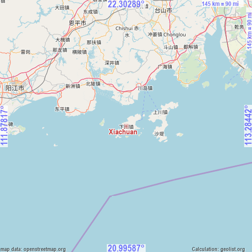
Xiachuan GPS coordinates[2]
21° 39' 3.096" North, 112° 34' 52.644" East
| Map corner | latitude | longitude |
|---|---|---|
| Upper-left | 22.30289°, | 111.87817° |
| Center: | 21.65086°, | 112.58129° |
| Lower-right: | 20.99587°, | 113.28442° |
| Map W x H: | 145.3×145.3 km | = 90.3×90.3mi |
| max Lat: | 53.31946° ⇑97.8% North |
| Xiachuan: | 21.65086° |
| min Lat: | ⇓2.2% South 18.22056° |
| min Long | Xiachuan | max Long |
| 75.07348° | 112.58129° | 134.28917° |
| W 40.4%⇐ | ⇒59.6% E |
Elevation
Elevation of Xiachuan is 1 m = 3 ft, and this is 483.8 m = 1587 ft below average elevation for this country.
| Max E: |
5622 m = 18445 ft | 99.7% |
| Avg. | 484.8 m = 1591 ft | |
| Xiachuan | 1 m = 3 ft | |
Min E: |
-3 m = -10 ft | 0.3% |
See also: China elevation on elevation.city.
Geographical zone
Xiachuan is located in North Torrid zone (between Equator and Tropic of Cancer). Distance of this Northern Tropic circle is 198.6 km =123.4 mi to North.| Distance of | km | miles | from Xiachuan |
|---|---|---|---|
| North Pole | 7599.7 | 4722.2 | to North |
| Arctic Circle | 4993.8 | 3103 | to North |
| Tropic Cancer | 198.6 | 123.4 | to North |
| Equator | 2407.3 | 1495.8 | to South |


Nearby cities:
15 places around Xiachuan: (largest is in red/bold)
• Beidou
32 km =19.9 mi,  321°
321°
• Chishui
54.5 km =33.9 mi,  0°
0°
• Chixi
47.7 km =29.6 mi,  42°
42°
• Chuandao
24.8 km =15.4 mi,  24°
24°
• Dagou
48.4 km =30.1 mi,  295°
295°
• Dongping
38.9 km =24.2 mi,  284°
284°
• Doushan
52.7 km =32.7 mi,  29°
29°
• Duanfen
48.7 km =30.3 mi, 21°
• Guanghai
40.9 km =25.4 mi, 32°
• Haiyan
20.2 km =12.6 mi,  348°
348°
• Hengpi
50.9 km =31.6 mi,  327°
327°
• Shangchuan
21.3 km =13.2 mi,  66°
66°
• Shenjing
38.1 km =23.7 mi, 345°
• Wencun
25.2 km =15.7 mi,  339°
339°
• Xinzhou
38.7 km =24 mi,  306°
306°
Sources, notices
• [Note1] Compared only with cities in China existing in our database
• [Src1] Map data: © OpenStreetMap contributors (CC-BY-SA)
• [Src2] Other city data from geonames.org with taken over terms of usage.
• [Src3] Geographical zone / Annual Mean Temperature by Robert A. Rohde @ Wikipedia
