Shenjing geodata
Shenjing (Guangdong) is a seat of a fourth-order administrative division; located in China in Asia/Shanghai (GMT+8) time zone. In our database, there are 1268 cities with bigger population. Compared to other cities in China, 97.3% of cities are located further ↑North; 60.1% of cities are located further →East and 95.9% of cities have higher elevation than Shenjing. Note1


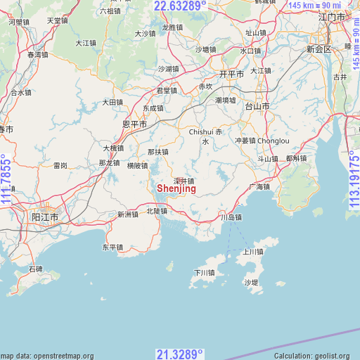
Shenjing GPS coordinates[2]
21° 58' 56.604" North, 112° 29' 19.032" East
| Map corner | latitude | longitude |
|---|---|---|
| Upper-left | 22.63289°, | 111.7855° |
| Center: | 21.98239°, | 112.48862° |
| Lower-right: | 21.3289°, | 113.19175° |
| Map W x H: | 145×145 km | = 90.1×90.1mi |
| max Lat: | 53.31946° ⇑97.3% North |
| Shenjing: | 21.98239° |
| min Lat: | ⇓2.7% South 18.22056° |
| min Long | Shenjing | max Long |
| 75.07348° | 112.48862° | 134.28917° |
| W 39.9%⇐ | ⇒60.1% E |
Elevation
Elevation of Shenjing is 6 m = 20 ft, and this is 478.8 m = 1571 ft below average elevation for this country.
| Max E: |
5622 m = 18445 ft | 95.9% |
| Avg. | 484.8 m = 1591 ft | |
| Shenjing | 6 m = 20 ft | |
Min E: |
-3 m = -10 ft | 4.1% |
See also: China elevation on elevation.city.
Geographical zone
Shenjing is located in North Torrid zone (between Equator and Tropic of Cancer). Distance of this Northern Tropic circle is 161.7 km =100.5 mi to North.| Distance of | km | miles | from Shenjing |
|---|---|---|---|
| North Pole | 7562.8 | 4699.3 | to North |
| Arctic Circle | 4957 | 3080.1 | to North |
| Tropic Cancer | 161.7 | 100.5 | to North |
| Equator | 2444.2 | 1518.8 | to South |


Nearby cities:
15 places around Shenjing: (largest is in red/bold)
• Beidou
15.6 km =9.7 mi,  221°
221°
• Chishui
20.3 km =12.6 mi,  30°
30°
• Chuandao
24.3 km =15.1 mi,  125°
125°
• Dahuai
29.7 km =18.5 mi,  295°
295°
• Dongcheng
31.3 km =19.4 mi,  339°
339°
• Duanfen
28.7 km =17.8 mi,  72°
72°
• Encheng
29.6 km =18.4 mi,  320°
320°
• Guanghai
31.5 km =19.6 mi,  94°
94°
• Haiyan
18 km =11.2 mi,  161°
161°
• Hengpi
18.6 km =11.6 mi,  289°
289°
• Jinji
20.5 km =12.7 mi,  358°
358°
• Nalong
29.5 km =18.3 mi,  281°
281°
• Pingshi
29.8 km =18.5 mi,  325°
325°
• Wencun
13.3 km =8.3 mi,  177°
177°
• Xinzhou
25.6 km =15.9 mi,  237°
237°
Sources, notices
• [Note1] Compared only with cities in China existing in our database
• [Src1] Map data: © OpenStreetMap contributors (CC-BY-SA)
• [Src2] Other city data from geonames.org with taken over terms of usage.
• [Src3] Geographical zone / Annual Mean Temperature by Robert A. Rohde @ Wikipedia
