Tuzhu geodata
Tuzhu (Chongqing) is a seat of a fourth-order administrative division; located in China in Asia/Shanghai (GMT+8) time zone. In our database, there are 1268 cities with bigger population. Compared to other cities in China, 58.1% of cities are located further ↑North; 85.6% of cities are located further →East and 62.3% of cities have lower elevation than Tuzhu. Note1


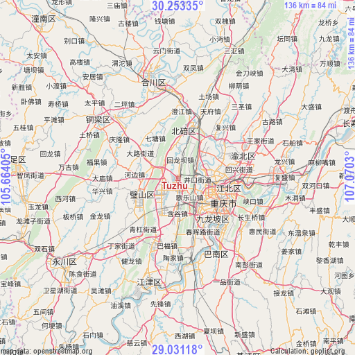
Tuzhu GPS coordinates[2]
29° 38' 38.832" North, 106° 22' 1.812" East
| Map corner | latitude | longitude |
|---|---|---|
| Upper-left | 30.25335°, | 105.66405° |
| Center: | 29.64412°, | 106.36717° |
| Lower-right: | 29.03118°, | 107.0703° |
| Map W x H: | 135.9×135.9 km | = 84.4×84.4mi |
| max Lat: | 53.31946° ⇑58.1% North |
| Tuzhu: | 29.64412° |
| min Lat: | ⇓41.9% South 18.22056° |
| min Long | Tuzhu | max Long |
| 75.07348° | 106.36717° | 134.28917° |
| W 14.4%⇐ | ⇒85.6% E |
Elevation
Elevation of Tuzhu is 287 m = 942 ft, and this is 197.8 m = 649 ft below average elevation for this country.
| Max E: |
5622 m = 18445 ft | 37.7% |
| Avg. | 484.8 m = 1591 ft | |
| Tuzhu | 287 m = 942 ft | |
Min E: |
-3 m = -10 ft | 62.3% |
See also: China elevation on elevation.city.
Geographical zone
Tuzhu is located in North temperate zone (between Tropic of Cancer and the Arctic Circle). Distance of this Northern Tropic circle is 690.2 km =428.9 mi to South.| Distance of | km | miles | from Tuzhu |
|---|---|---|---|
| North Pole | 6710.9 | 4170 | to North |
| Arctic Circle | 4105.1 | 2550.8 | to North |
| Tropic Cancer | 690.2 | 428.9 | to South |
| Equator | 3296.1 | 2048.1 | to South |


Nearby cities:
15 places around Tuzhu: (largest is in red/bold)
• Baishiyi
16.9 km =10.5 mi,  175°
175°
• Bicheng
14.8 km =9.2 mi,  248°
248°
• Caijiagang
15.1 km =9.4 mi,  43°
43°
• Dazhulin
9.4 km =5.8 mi,  101°
101°
• Geleshan
8.6 km =5.3 mi,  149°
149°
• Hebian
16.5 km =10.3 mi,  274°
274°
• Huilongba
6.8 km =4.2 mi,  6°
6°
• Huxi
7.8 km =4.8 mi,  229°
229°
• Jinfeng
15.8 km =9.8 mi,  194°
194°
• Lijia
12.8 km =8 mi,  72°
72°
• Qingmuguan
7.8 km =4.8 mi,  296°
296°
• Renhe
15.5 km =9.6 mi, 98°
• Tongjiaxi
8.7 km =5.4 mi,  58°
58°
• Xiema
14.5 km =9 mi,  0°
0°
• Zengjia
12.4 km =7.7 mi,  212°
212°
Sources, notices
• [Note1] Compared only with cities in China existing in our database
• [Src1] Map data: © OpenStreetMap contributors (CC-BY-SA)
• [Src2] Other city data from geonames.org with taken over terms of usage.
• [Src3] Geographical zone / Annual Mean Temperature by Robert A. Rohde @ Wikipedia
