Tongjiaxi geodata
Tongjiaxi (Chongqing) is a seat of a fourth-order administrative division; located in China in Asia/Shanghai (GMT+8) time zone. In our database, there are 1268 cities with bigger population. Compared to other cities in China, 57.6% of cities are located further ↑North; 85.3% of cities are located further →East and 55% of cities have lower elevation than Tongjiaxi. Note1


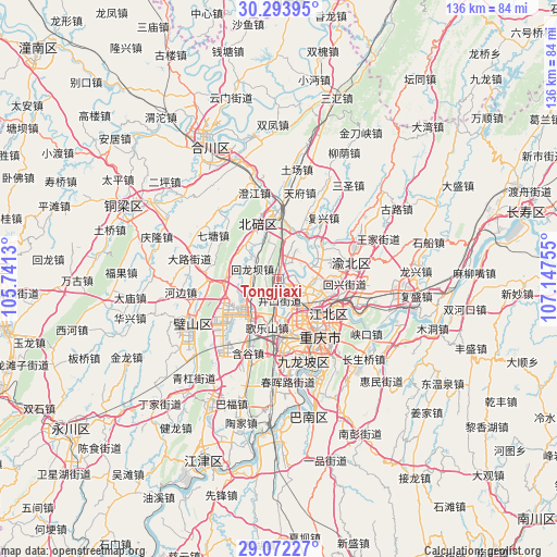
Tongjiaxi GPS coordinates[2]
29° 41' 5.892" North, 106° 26' 39.912" East
| Map corner | latitude | longitude |
|---|---|---|
| Upper-left | 30.29395°, | 105.7413° |
| Center: | 29.68497°, | 106.44442° |
| Lower-right: | 29.07227°, | 107.14755° |
| Map W x H: | 135.8×135.8 km | = 84.4×84.4mi |
| max Lat: | 53.31946° ⇑57.6% North |
| Tongjiaxi: | 29.68497° |
| min Lat: | ⇓42.4% South 18.22056° |
| min Long | Tongjiaxi | max Long |
| 75.07348° | 106.44442° | 134.28917° |
| W 14.7%⇐ | ⇒85.3% E |
Elevation
Elevation of Tongjiaxi is 207 m = 679 ft, and this is 277.8 m = 911 ft below average elevation for this country.
| Max E: |
5622 m = 18445 ft | 45% |
| Avg. | 484.8 m = 1591 ft | |
| Tongjiaxi | 207 m = 679 ft | |
Min E: |
-3 m = -10 ft | 55% |
See also: China elevation on elevation.city.
Geographical zone
Tongjiaxi is located in North temperate zone (between Tropic of Cancer and the Arctic Circle). Distance of this Northern Tropic circle is 694.7 km =431.7 mi to South.| Distance of | km | miles | from Tongjiaxi |
|---|---|---|---|
| North Pole | 6706.4 | 4167.2 | to North |
| Arctic Circle | 4100.5 | 2547.9 | to North |
| Tropic Cancer | 694.7 | 431.7 | to South |
| Equator | 3300.7 | 2051 | to South |


Nearby cities:
15 places around Tongjiaxi: (largest is in red/bold)
• Beibei
15.9 km =9.9 mi,  357°
357°
• Caijiagang
7 km =4.3 mi,  24°
24°
• Cuntan
15.3 km =9.5 mi,  126°
126°
• Dazhulin
6.6 km =4.1 mi,  164°
164°
• Geleshan
12.3 km =7.6 mi,  194°
194°
• Huilongba
7 km =4.3 mi,  288°
288°
• Lijia
4.8 km =3 mi,  98°
98°
• Longfeng
14.6 km =9.1 mi,  354°
354°
• Qingmuguan
14.4 km =8.9 mi,  265°
265°
• Renhe
10.3 km =6.4 mi, 130°
• Shijialiang
11.8 km =7.3 mi,  13°
13°
• Shuitu
12 km =7.5 mi,  25°
25°
• Tuzhu
8.7 km =5.4 mi,  238°
238°
• Xiema
12.3 km =7.6 mi,  323°
323°
• Yuanyang
11.1 km =6.9 mi, 101°
Sources, notices
• [Note1] Compared only with cities in China existing in our database
• [Src1] Map data: © OpenStreetMap contributors (CC-BY-SA)
• [Src2] Other city data from geonames.org with taken over terms of usage.
• [Src3] Geographical zone / Annual Mean Temperature by Robert A. Rohde @ Wikipedia
