Renhe geodata
Renhe (Chongqing) is a seat of a fourth-order administrative division; located in China in Asia/Shanghai (GMT+8) time zone. In our database, there are 1268 cities with bigger population. Compared to other cities in China, 58.3% of cities are located further ↑North; 85.1% of cities are located further →East and 66.5% of cities have lower elevation than Renhe. Note1


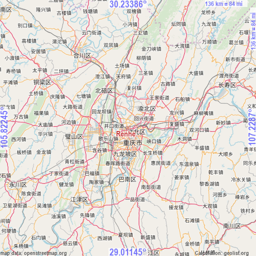
Renhe GPS coordinates[2]
29° 37' 28.236" North, 106° 31' 32.052" East
| Map corner | latitude | longitude |
|---|---|---|
| Upper-left | 30.23386°, | 105.82245° |
| Center: | 29.62451°, | 106.52557° |
| Lower-right: | 29.01145°, | 107.2287° |
| Map W x H: | 135.9×135.9 km | = 84.4×84.4mi |
| max Lat: | 53.31946° ⇑58.3% North |
| Renhe: | 29.62451° |
| min Lat: | ⇓41.7% South 18.22056° |
| min Long | Renhe | max Long |
| 75.07348° | 106.52557° | 134.28917° |
| W 14.9%⇐ | ⇒85.1% E |
Elevation
Elevation of Renhe is 352 m = 1155 ft, and this is 132.8 m = 436 ft below average elevation for this country.
| Max E: |
5622 m = 18445 ft | 33.5% |
| Avg. | 484.8 m = 1591 ft | |
| Renhe | 352 m = 1155 ft | |
Min E: |
-3 m = -10 ft | 66.5% |
See also: China elevation on elevation.city.
Geographical zone
Renhe is located in North temperate zone (between Tropic of Cancer and the Arctic Circle). Distance of this Northern Tropic circle is 688 km =427.5 mi to South.| Distance of | km | miles | from Renhe |
|---|---|---|---|
| North Pole | 6713.1 | 4171.3 | to North |
| Arctic Circle | 4107.2 | 2552.1 | to North |
| Tropic Cancer | 688 | 427.5 | to South |
| Equator | 3293.9 | 2046.7 | to South |


Nearby cities:
15 places around Renhe: (largest is in red/bold)
• Caijiagang
14 km =8.7 mi,  339°
339°
• Chongqing
7.4 km =4.6 mi,  159°
159°
• Cuntan
5 km =3.1 mi,  119°
119°
• Dazhulin
6.1 km =3.8 mi,  273°
273°
• Geleshan
12.1 km =7.5 mi,  244°
244°
• Huixing
10.9 km =6.8 mi,  52°
52°
• Jiguanshi
8.3 km =5.2 mi,  113°
113°
• Lijia
6.8 km =4.2 mi,  332°
332°
• Nanping
11.1 km =6.9 mi,  147°
147°
• Shuangfengqiao
14.3 km =8.9 mi,  43°
43°
• Tongjiaxi
10.3 km =6.4 mi,  310°
310°
• Tuzhu
15.5 km =9.6 mi,  278°
278°
• Yangjiaping
13.5 km =8.4 mi,  190°
190°
• Yuanyang
5.5 km =3.4 mi,  33°
33°
• Yufengshan
14.2 km =8.8 mi,  72°
72°
Sources, notices
• [Note1] Compared only with cities in China existing in our database
• [Src1] Map data: © OpenStreetMap contributors (CC-BY-SA)
• [Src2] Other city data from geonames.org with taken over terms of usage.
• [Src3] Geographical zone / Annual Mean Temperature by Robert A. Rohde @ Wikipedia
