Hetai geodata
Hetai (Guangdong) is a seat of a fourth-order administrative division; located in China in Asia/Shanghai (GMT+8) time zone. In our database, there are 1268 cities with bigger population. Compared to other cities in China, 92.9% of cities are located further ↑North; 61.3% of cities are located further →East and 54.9% of cities have higher elevation than Hetai. Note1


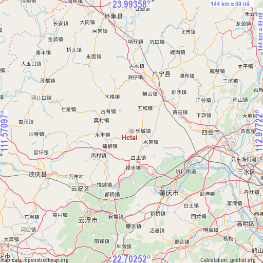
Hetai GPS coordinates[2]
23° 20' 58.632" North, 112° 16' 26.724" East
| Map corner | latitude | longitude |
|---|---|---|
| Upper-left | 23.99358°, | 111.57097° |
| Center: | 23.34962°, | 112.27409° |
| Lower-right: | 22.70252°, | 112.97722° |
| Map W x H: | 143.6×143.6 km | = 89.2×89.2mi |
| max Lat: | 53.31946° ⇑92.9% North |
| Hetai: | 23.34962° |
| min Lat: | ⇓7.1% South 18.22056° |
| min Long | Hetai | max Long |
| 75.07348° | 112.27409° | 134.28917° |
| W 38.7%⇐ | ⇒61.3% E |
Elevation
Elevation of Hetai is 132 m = 433 ft, and this is 352.8 m = 1157 ft below average elevation for this country.
| Max E: |
5622 m = 18445 ft | 54.9% |
| Avg. | 484.8 m = 1591 ft | |
| Hetai | 132 m = 433 ft | |
Min E: |
-3 m = -10 ft | 45.1% |
See also: China elevation on elevation.city.
Geographical zone
Hetai is located in North Torrid zone (between Equator and Tropic of Cancer). Distance of this Northern Tropic circle is 9.7 km =6 mi to North.| Distance of | km | miles | from Hetai |
|---|---|---|---|
| North Pole | 7410.8 | 4604.9 | to North |
| Arctic Circle | 4804.9 | 2985.6 | to North |
| Tropic Cancer | 9.7 | 6 | to North |
| Equator | 2596.2 | 1613.2 | to South |


Nearby cities:
15 places around Hetai: (largest is in red/bold)
• Binheng
20.2 km =12.6 mi,  48°
48°
• Bozhi
14.3 km =8.9 mi,  234°
234°
• Fengcun
22.6 km =14 mi, 234°
• Hengshan
22.5 km =14 mi,  26°
26°
• Huangtian
28.4 km =17.6 mi,  67°
67°
• Lecheng
6 km =3.7 mi,  85°
85°
• Lubu
19.7 km =12.2 mi,  177°
177°
• Mocun
18.3 km =11.4 mi,  291°
291°
• Muge
21.4 km =13.3 mi,  330°
330°
• Shijian
26.5 km =16.5 mi, 45°
• Shuinan
11.1 km =6.9 mi,  118°
118°
• Wuhe
13.1 km =8.1 mi, 33°
• Wulong
9.3 km =5.8 mi,  251°
251°
• Xiaoxiang
26.1 km =16.2 mi,  153°
153°
• Yongfeng
15.7 km =9.8 mi,  266°
266°
Sources, notices
• [Note1] Compared only with cities in China existing in our database
• [Src1] Map data: © OpenStreetMap contributors (CC-BY-SA)
• [Src2] Other city data from geonames.org with taken over terms of usage.
• [Src3] Geographical zone / Annual Mean Temperature by Robert A. Rohde @ Wikipedia
