Lubu geodata
Lubu (Guangdong) is a seat of a fourth-order administrative division; located in China in Asia/Shanghai (GMT+8) time zone. With population of 95,820 people, there are 439 cities with bigger population in this country. Compared to other cities in China, 93.6% of cities are located further ↑North; 61.2% of cities are located further →East and 83.9% of cities have higher elevation than Lubu. Note1


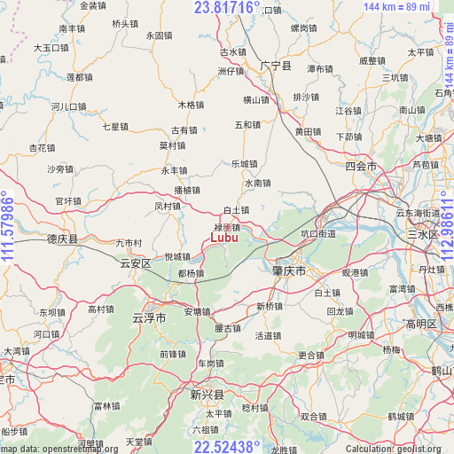
Lubu GPS coordinates[2]
23° 10' 20.388" North, 112° 16' 58.728" East
| Map corner | latitude | longitude |
|---|---|---|
| Upper-left | 23.81716°, | 111.57986° |
| Center: | 23.17233°, | 112.28298° |
| Lower-right: | 22.52438°, | 112.98611° |
| Map W x H: | 143.7×143.7 km | = 89.3×89.3mi |
| max Lat: | 53.31946° ⇑93.6% North |
| Lubu: | 23.17233° |
| min Lat: | ⇓6.4% South 18.22056° |
| min Long | Lubu | max Long |
| 75.07348° | 112.28298° | 134.28917° |
| W 38.8%⇐ | ⇒61.2% E |
Elevation
Elevation of Lubu is 18 m = 59 ft, and this is 466.8 m = 1531 ft below average elevation for this country.
| Max E: |
5622 m = 18445 ft | 83.9% |
| Avg. | 484.8 m = 1591 ft | |
| Lubu | 18 m = 59 ft | |
Min E: |
-3 m = -10 ft | 16.1% |
See also: Lubu elevation on elevation.city.
Geographical zone
Lubu is located in North Torrid zone (between Equator and Tropic of Cancer). Distance of this Northern Tropic circle is 29.4 km =18.3 mi to North.| Distance of | km | miles | from Lubu |
|---|---|---|---|
| North Pole | 7430.5 | 4617.1 | to North |
| Arctic Circle | 4824.7 | 2997.9 | to North |
| Tropic Cancer | 29.4 | 18.3 | to North |
| Equator | 2576.5 | 1601 | to South |


Nearby cities:
15 places around Lubu: (largest is in red/bold)
• Bozhi
17 km =10.6 mi,  312°
312°
• Chengbei
22.4 km =13.9 mi,  126°
126°
• Chengxi
22.4 km =13.9 mi, 130°
• Dawan
18.4 km =11.4 mi,  140°
140°
• Duyang
21.9 km =13.6 mi,  218°
218°
• Fengcun
20.5 km =12.7 mi,  289°
289°
• Hetai
19.7 km =12.2 mi,  357°
357°
• Lecheng
20.8 km =12.9 mi,  14°
14°
• Mugang
17.8 km =11.1 mi, 130°
• Nan’an
23.3 km =14.5 mi, 132°
• Shuinan
16.9 km =10.5 mi,  31°
31°
• Wulong
19.4 km =12.1 mi,  329°
329°
• Xiaoxiang
11.2 km =7 mi,  109°
109°
• Yuecheng
18.2 km =11.3 mi,  240°
240°
• Zhaoqing
22.8 km =14.2 mi, 127°
Sources, notices
• [Note1] Compared only with cities in China existing in our database
• [Src1] Map data: © OpenStreetMap contributors (CC-BY-SA)
• [Src2] Other city data from geonames.org with taken over terms of usage.
• [Src3] Geographical zone / Annual Mean Temperature by Robert A. Rohde @ Wikipedia
