Shuinan geodata
Shuinan (Guangdong) is a seat of a fourth-order administrative division; located in China in Asia/Shanghai (GMT+8) time zone. In our database, there are 1268 cities with bigger population. Compared to other cities in China, 93% of cities are located further ↑North; 60.8% of cities are located further →East and 56.9% of cities have lower elevation than Shuinan. Note1


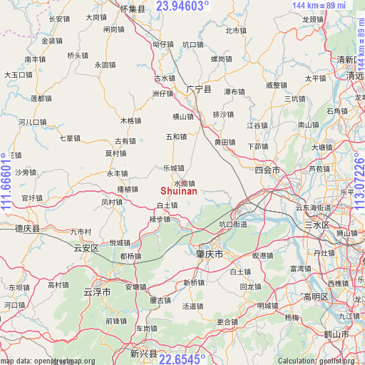
Shuinan GPS coordinates[2]
23° 18' 6.588" North, 112° 22' 8.868" East
| Map corner | latitude | longitude |
|---|---|---|
| Upper-left | 23.94603°, | 111.66601° |
| Center: | 23.30183°, | 112.36913° |
| Lower-right: | 22.6545°, | 113.07226° |
| Map W x H: | 143.6×143.6 km | = 89.2×89.2mi |
| max Lat: | 53.31946° ⇑93% North |
| Shuinan: | 23.30183° |
| min Lat: | ⇓7% South 18.22056° |
| min Long | Shuinan | max Long |
| 75.07348° | 112.36913° | 134.28917° |
| W 39.2%⇐ | ⇒60.8% E |
Elevation
Elevation of Shuinan is 225 m = 738 ft, and this is 259.8 m = 852 ft below average elevation for this country.
| Max E: |
5622 m = 18445 ft | 43.1% |
| Avg. | 484.8 m = 1591 ft | |
| Shuinan | 225 m = 738 ft | |
Min E: |
-3 m = -10 ft | 56.9% |
See also: China elevation on elevation.city.
Geographical zone
Shuinan is located in North Torrid zone (between Equator and Tropic of Cancer). Distance of this Northern Tropic circle is 15 km =9.3 mi to North.| Distance of | km | miles | from Shuinan |
|---|---|---|---|
| North Pole | 7416.1 | 4608.1 | to North |
| Arctic Circle | 4810.3 | 2989 | to North |
| Tropic Cancer | 15 | 9.3 | to North |
| Equator | 2590.9 | 1609.9 | to South |


Nearby cities:
15 places around Shuinan: (largest is in red/bold)
• Binheng
19.5 km =12.1 mi,  15°
15°
• Bozhi
21.6 km =13.4 mi,  262°
262°
• Fenghuang
22.9 km =14.2 mi,  118°
118°
• Guicheng
23.9 km =14.9 mi, 120°
• Hengshan
25.5 km =15.8 mi,  0°
0°
• Hetai
11.1 km =6.9 mi,  298°
298°
• Huangtian
23.1 km =14.4 mi,  45°
45°
• Kengkou
25.4 km =15.8 mi,  130°
130°
• Lecheng
6.9 km =4.3 mi,  326°
326°
• Lubu
16.9 km =10.5 mi,  211°
211°
• Shigou
22.1 km =13.7 mi,  69°
69°
• Shijian
25.6 km =15.9 mi, 20°
• Wuhe
16.4 km =10.2 mi,  351°
351°
• Wulong
18.7 km =11.6 mi,  277°
277°
• Xiaoxiang
18.3 km =11.4 mi,  174°
174°
Sources, notices
• [Note1] Compared only with cities in China existing in our database
• [Src1] Map data: © OpenStreetMap contributors (CC-BY-SA)
• [Src2] Other city data from geonames.org with taken over terms of usage.
• [Src3] Geographical zone / Annual Mean Temperature by Robert A. Rohde @ Wikipedia
