Zhongping geodata
Zhongping (Hainan) is a seat of a fourth-order administrative division; located in China in Asia/Shanghai (GMT+8) time zone. In our database, there are 1268 cities with bigger population. Compared to other cities in China, 99.6% of cities are located further ↑North; 71% of cities are located further →East and 50.9% of cities have higher elevation than Zhongping. Note1


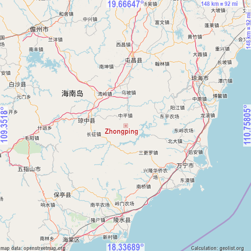
Zhongping GPS coordinates[2]
19° 0' 10.836" North, 110° 3' 17.712" East
| Map corner | latitude | longitude |
|---|---|---|
| Upper-left | 19.66647°, | 109.3518° |
| Center: | 19.00301°, | 110.05492° |
| Lower-right: | 18.33689°, | 110.75805° |
| Map W x H: | 147.8×147.8 km | = 91.8×91.8mi |
| max Lat: | 53.31946° ⇑99.6% North |
| Zhongping: | 19.00301° |
| min Lat: | ⇓0.4% South 18.22056° |
| min Long | Zhongping | max Long |
| 75.07348° | 110.05492° | 134.28917° |
| W 29%⇐ | ⇒71% E |
Elevation
Elevation of Zhongping is 157 m = 515 ft, and this is 327.8 m = 1075 ft below average elevation for this country.
| Max E: |
5622 m = 18445 ft | 50.9% |
| Avg. | 484.8 m = 1591 ft | |
| Zhongping | 157 m = 515 ft | |
Min E: |
-3 m = -10 ft | 49.1% |
See also: China elevation on elevation.city.
Geographical zone
Zhongping is located in North Torrid zone (between Equator and Tropic of Cancer). Distance of this Northern Tropic circle is 493 km =306.3 mi to North.| Distance of | km | miles | from Zhongping |
|---|---|---|---|
| North Pole | 7894.1 | 4905.2 | to North |
| Arctic Circle | 5288.2 | 3285.9 | to North |
| Tropic Cancer | 493 | 306.3 | to North |
| Equator | 2112.9 | 1312.9 | to South |


Nearby cities:
15 places around Zhongping: (largest is in red/bold)
• Beida
30.3 km =18.8 mi,  106°
106°
• Changzheng
19.5 km =12.1 mi,  256°
256°
• Diaoluoshan
29.9 km =18.6 mi,  219°
219°
• Fengmu
23.5 km =14.6 mi,  347°
347°
• Heping
11.9 km =7.4 mi,  198°
198°
• Huishan
22.9 km =14.2 mi,  71°
71°
• Longjiang
32.2 km =20 mi,  59°
59°
• Nanlü
27.6 km =17.1 mi,  4°
4°
• Sangengluo
20.4 km =12.7 mi,  139°
139°
• Shang’an
27.2 km =16.9 mi,  239°
239°
• Shibi
31.7 km =19.7 mi, 55°
• Wanling
22.9 km =14.2 mi,  326°
326°
• Wupo
20.2 km =12.6 mi, 3°
• Yangjiang
32.2 km =20 mi, 70°
• Yinggen
22.9 km =14.2 mi,  279°
279°
Sources, notices
• [Note1] Compared only with cities in China existing in our database
• [Src1] Map data: © OpenStreetMap contributors (CC-BY-SA)
• [Src2] Other city data from geonames.org with taken over terms of usage.
• [Src3] Geographical zone / Annual Mean Temperature by Robert A. Rohde @ Wikipedia
