Changzheng geodata
Changzheng (Hainan) is a seat of a fourth-order administrative division; located in China in Asia/Shanghai (GMT+8) time zone. In our database, there are 1268 cities with bigger population. Compared to other cities in China, 99.6% of cities are located further ↑North; 71.9% of cities are located further →East and 65.9% of cities have lower elevation than Changzheng. Note1


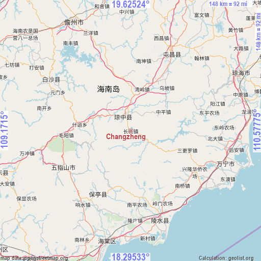
Changzheng GPS coordinates[2]
18° 57' 41.796" North, 109° 52' 28.632" East
| Map corner | latitude | longitude |
|---|---|---|
| Upper-left | 19.62524°, | 109.1715° |
| Center: | 18.96161°, | 109.87462° |
| Lower-right: | 18.29533°, | 110.57775° |
| Map W x H: | 147.9×147.9 km | = 91.9×91.9mi |
| max Lat: | 53.31946° ⇑99.6% North |
| Changzheng: | 18.96161° |
| min Lat: | ⇓0.4% South 18.22056° |
| min Long | Changzheng | max Long |
| 75.07348° | 109.87462° | 134.28917° |
| W 28.1%⇐ | ⇒71.9% E |
Elevation
Elevation of Changzheng is 341 m = 1119 ft, and this is 143.8 m = 472 ft below average elevation for this country.
| Max E: |
5622 m = 18445 ft | 34.1% |
| Avg. | 484.8 m = 1591 ft | |
| Changzheng | 341 m = 1119 ft | |
Min E: |
-3 m = -10 ft | 65.9% |
See also: China elevation on elevation.city.
Geographical zone
Changzheng is located in North Torrid zone (between Equator and Tropic of Cancer). Distance of this Northern Tropic circle is 497.6 km =309.2 mi to North.| Distance of | km | miles | from Changzheng |
|---|---|---|---|
| North Pole | 7898.7 | 4908 | to North |
| Arctic Circle | 5292.8 | 3288.8 | to North |
| Tropic Cancer | 497.6 | 309.2 | to North |
| Equator | 2108.3 | 1310 | to South |


Nearby cities:
15 places around Changzheng: (largest is in red/bold)
• Diaoluoshan
18.5 km =11.5 mi,  180°
180°
• Fengmu
30.9 km =19.2 mi,  27°
27°
• Heping
16.7 km =10.4 mi,  113°
113°
• Hongmao
23.1 km =14.4 mi,  287°
287°
• Limushan
35.4 km =22 mi,  344°
344°
• Maoyang
35.7 km =22.2 mi,  264°
264°
• Nanlü
38.4 km =23.9 mi, 33°
• Sangengluo
34 km =21.1 mi, 108°
• Shang’an
10.3 km =6.4 mi,  205°
205°
• Shiling
34.6 km =21.5 mi,  196°
196°
• Shiyun
29 km =18 mi,  277°
277°
• Wanling
24.6 km =15.3 mi,  15°
15°
• Wupo
32 km =19.9 mi,  39°
39°
• Yinggen
9.3 km =5.8 mi, 336°
• Zhongping
19.5 km =12.1 mi,  76°
76°
Sources, notices
• [Note1] Compared only with cities in China existing in our database
• [Src1] Map data: © OpenStreetMap contributors (CC-BY-SA)
• [Src2] Other city data from geonames.org with taken over terms of usage.
• [Src3] Geographical zone / Annual Mean Temperature by Robert A. Rohde @ Wikipedia
