Lingbei geodata
Lingbei (Guangdong) is a seat of a fourth-order administrative division; located in China in Asia/Urumqi (GMT+6) time zone. In our database, there are 1268 cities with bigger population. Compared to other cities in China, 98.3% of cities are located further ↑North; 70.5% of cities are located further →East and 56% of cities have higher elevation than Lingbei. Note1


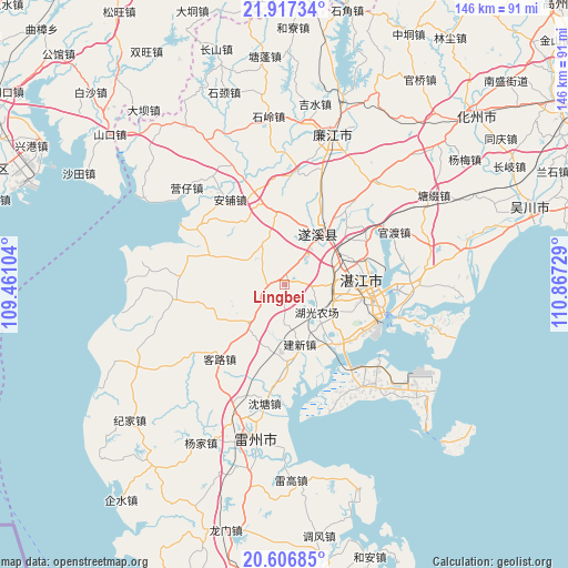
Lingbei GPS coordinates[2]
21° 15' 48.78" North, 110° 9' 50.976" East
| Map corner | latitude | longitude |
|---|---|---|
| Upper-left | 21.91734°, | 109.46104° |
| Center: | 21.26355°, | 110.16416° |
| Lower-right: | 20.60685°, | 110.86729° |
| Map W x H: | 145.7×145.7 km | = 90.5×90.5mi |
| max Lat: | 53.31946° ⇑98.3% North |
| Lingbei: | 21.26355° |
| min Lat: | ⇓1.7% South 18.22056° |
| min Long | Lingbei | max Long |
| 75.07348° | 110.16416° | 134.28917° |
| W 29.5%⇐ | ⇒70.5% E |
Elevation
Elevation of Lingbei is 124 m = 407 ft, and this is 360.8 m = 1184 ft below average elevation for this country.
| Max E: |
5622 m = 18445 ft | 56% |
| Avg. | 484.8 m = 1591 ft | |
| Lingbei | 124 m = 407 ft | |
Min E: |
-3 m = -10 ft | 44% |
See also: China elevation on elevation.city.
Geographical zone
Lingbei is located in North Torrid zone (between Equator and Tropic of Cancer). Distance of this Northern Tropic circle is 241.6 km =150.1 mi to North.| Distance of | km | miles | from Lingbei |
|---|---|---|---|
| North Pole | 7642.8 | 4749 | to North |
| Arctic Circle | 5036.9 | 3129.8 | to North |
| Tropic Cancer | 241.6 | 150.1 | to North |
| Equator | 2364.3 | 1469.1 | to South |


Nearby cities:
15 places around Lingbei: (largest is in red/bold)
• Anpu
25.6 km =15.9 mi,  326°
326°
• Chengyue
14.4 km =8.9 mi,  221°
221°
• Chikan
20.2 km =12.6 mi,  87°
87°
• Gongnong
25.2 km =15.7 mi,  108°
108°
• Haitou
24.1 km =15 mi, 106°
• Huguang
20 km =12.4 mi,  139°
139°
• Jianxin
16.9 km =10.5 mi,  166°
166°
• Kelu
24.9 km =15.5 mi, 217°
• Mazhang
16.4 km =10.2 mi, 85°
• Nanqiao
20.2 km =12.6 mi, 88°
• Suicheng
15.7 km =9.8 mi,  34°
34°
• Taiping
24.4 km =15.2 mi,  181°
181°
• Wutang
16.9 km =10.5 mi,  269°
269°
• Yangqing
11.6 km =7.2 mi, 330°
• Zhanjiang
18.6 km =11.6 mi,  83°
83°
Sources, notices
• [Note1] Compared only with cities in China existing in our database
• [Src1] Map data: © OpenStreetMap contributors (CC-BY-SA)
• [Src2] Other city data from geonames.org with taken over terms of usage.
• [Src3] Geographical zone / Annual Mean Temperature by Robert A. Rohde @ Wikipedia
