Haitou geodata
Haitou (Guangdong) is a seat of a fourth-order administrative division; located in China in Asia/Urumqi (GMT+6) time zone. In our database, there are 1268 cities with bigger population. Compared to other cities in China, 98.4% of cities are located further ↑North; 69.6% of cities are located further →East and 82.1% of cities have higher elevation than Haitou. Note1


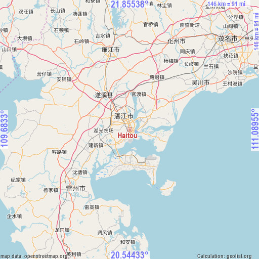
Haitou GPS coordinates[2]
21° 12' 4.716" North, 110° 23' 11.112" East
| Map corner | latitude | longitude |
|---|---|---|
| Upper-left | 21.85538°, | 109.6833° |
| Center: | 21.20131°, | 110.38642° |
| Lower-right: | 20.54433°, | 111.08955° |
| Map W x H: | 145.8×145.8 km | = 90.6×90.6mi |
| max Lat: | 53.31946° ⇑98.4% North |
| Haitou: | 21.20131° |
| min Lat: | ⇓1.6% South 18.22056° |
| min Long | Haitou | max Long |
| 75.07348° | 110.38642° | 134.28917° |
| W 30.4%⇐ | ⇒69.6% E |
Elevation
Elevation of Haitou is 22 m = 72 ft, and this is 462.8 m = 1518 ft below average elevation for this country.
| Max E: |
5622 m = 18445 ft | 82.1% |
| Avg. | 484.8 m = 1591 ft | |
| Haitou | 22 m = 72 ft | |
Min E: |
-3 m = -10 ft | 17.9% |
See also: China elevation on elevation.city.
Geographical zone
Haitou is located in North Torrid zone (between Equator and Tropic of Cancer). Distance of this Northern Tropic circle is 248.6 km =154.5 mi to North.| Distance of | km | miles | from Haitou |
|---|---|---|---|
| North Pole | 7649.7 | 4753.3 | to North |
| Arctic Circle | 5043.8 | 3134.1 | to North |
| Tropic Cancer | 248.6 | 154.5 | to North |
| Equator | 2357.4 | 1464.8 | to South |


Nearby cities:
15 places around Haitou: (largest is in red/bold)
• Chikan
8.3 km =5.2 mi,  339°
339°
• Dongjian
21.5 km =13.4 mi,  148°
148°
• Dongshan
18.5 km =11.5 mi,  178°
178°
• Gongnong
1.3 km =0.8 mi,  137°
137°
• Guandu
21 km =13 mi,  14°
14°
• Huguang
13.2 km =8.2 mi,  230°
230°
• Jianxin
21.3 km =13.2 mi,  243°
243°
• Longtou
22.3 km =13.9 mi,  38°
38°
• Mazhang
10.6 km =6.6 mi,  321°
321°
• Min’an
21.9 km =13.6 mi,  198°
198°
• Nandiao
8.3 km =5.2 mi,  47°
47°
• Nanqiao
7.9 km =4.9 mi, 338°
• Nansan
17.9 km =11.1 mi,  107°
107°
• Potou
9 km =5.6 mi,  34°
34°
• Zhanjiang
10 km =6.2 mi,  333°
333°
Sources, notices
• [Note1] Compared only with cities in China existing in our database
• [Src1] Map data: © OpenStreetMap contributors (CC-BY-SA)
• [Src2] Other city data from geonames.org with taken over terms of usage.
• [Src3] Geographical zone / Annual Mean Temperature by Robert A. Rohde @ Wikipedia
