Ligang geodata
Ligang (Guangdong) is a seat of a fourth-order administrative division; located in China in Asia/Urumqi (GMT+6) time zone. In our database, there are 1268 cities with bigger population. Compared to other cities in China, 97.6% of cities are located further ↑North; 68.6% of cities are located further →East and 79.3% of cities have higher elevation than Ligang. Note1


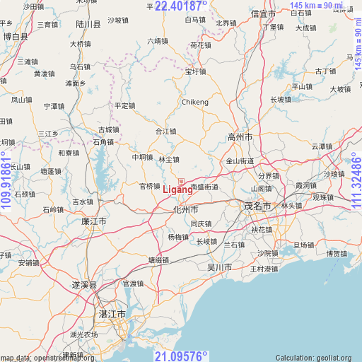
Ligang GPS coordinates[2]
21° 45' 1.08" North, 110° 37' 18.228" East
| Map corner | latitude | longitude |
|---|---|---|
| Upper-left | 22.40187°, | 109.91861° |
| Center: | 21.7503°, | 110.62173° |
| Lower-right: | 21.09576°, | 111.32486° |
| Map W x H: | 145.2×145.2 km | = 90.2×90.2mi |
| max Lat: | 53.31946° ⇑97.6% North |
| Ligang: | 21.7503° |
| min Lat: | ⇓2.4% South 18.22056° |
| min Long | Ligang | max Long |
| 75.07348° | 110.62173° | 134.28917° |
| W 31.4%⇐ | ⇒68.6% E |
Elevation
Elevation of Ligang is 28 m = 92 ft, and this is 456.8 m = 1499 ft below average elevation for this country.
| Max E: |
5622 m = 18445 ft | 79.3% |
| Avg. | 484.8 m = 1591 ft | |
| Ligang | 28 m = 92 ft | |
Min E: |
-3 m = -10 ft | 20.7% |
See also: China elevation on elevation.city.
Geographical zone
Ligang is located in North Torrid zone (between Equator and Tropic of Cancer). Distance of this Northern Tropic circle is 187.5 km =116.5 mi to North.| Distance of | km | miles | from Ligang |
|---|---|---|---|
| North Pole | 7588.7 | 4715.4 | to North |
| Arctic Circle | 4982.8 | 3096.2 | to North |
| Tropic Cancer | 187.5 | 116.5 | to North |
| Equator | 2418.4 | 1502.7 | to South |


Nearby cities:
15 places around Ligang: (largest is in red/bold)
• Dongshan
9.6 km =6 mi,  165°
165°
• Guanqiao
13.2 km =8.2 mi,  262°
262°
• Hexi
7.2 km =4.5 mi, 169°
• Hexi
11 km =6.8 mi,  180°
180°
• Huazhou
13.6 km =8.5 mi,  196°
196°
• Jianghu
13.5 km =8.4 mi,  352°
352°
• Linchen
10.3 km =6.4 mi,  331°
331°
• Nansheng
9.1 km =5.7 mi,  102°
102°
• Shatian
20 km =12.4 mi,  30°
30°
• Shigu
16.9 km =10.5 mi,  60°
60°
• Shiwan
12.7 km =7.9 mi,  223°
223°
• Tongqing
19 km =11.8 mi,  157°
157°
• Xiaguo
12.4 km =7.7 mi, 174°
• Zhenjiang
15.7 km =9.8 mi, 33°
• Zhongdong
18.5 km =11.5 mi,  301°
301°
Sources, notices
• [Note1] Compared only with cities in China existing in our database
• [Src1] Map data: © OpenStreetMap contributors (CC-BY-SA)
• [Src2] Other city data from geonames.org with taken over terms of usage.
• [Src3] Geographical zone / Annual Mean Temperature by Robert A. Rohde @ Wikipedia
