Xiachen geodata
Xiachen (Zhejiang) is a seat of a fourth-order administrative division; located in China in Asia/Shanghai (GMT+8) time zone. In our database, there are 1268 cities with bigger population. Compared to other cities in China, 60.7% of cities are located further ↑North; 79.9% of cities are located further ←West and 59.4% of cities have lower elevation than Xiachen. Note1


Xiachen GPS coordinates[2]
29° 24' 36.612" North, 119° 41' 24.144" East
| Map corner | latitude | longitude |
|---|---|---|
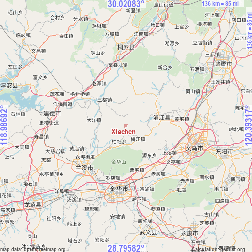
| Upper-left | 30.02083°, | 118.98692° |
| Center: | 29.41017°, | 119.69004° |
| Lower-right: | 28.79582°, | 120.39317° |
| Map W x H: | 136.2×136.2 km | = 84.6×84.6mi |
| max Lat: | 53.31946° ⇑60.7% North |
| Xiachen: | 29.41017° |
| min Lat: | ⇓39.3% South 18.22056° |
| min Long | Xiachen | max Long |
| 75.07348° | 119.69004° | 134.28917° |
| W 79.9%⇐ | ⇒20.1% E |
Elevation
Elevation of Xiachen is 252 m = 827 ft, and this is 232.8 m = 764 ft below average elevation for this country.
| Max E: |
5622 m = 18445 ft | 40.6% |
| Avg. | 484.8 m = 1591 ft | |
| Xiachen | 252 m = 827 ft | |
Min E: |
-3 m = -10 ft | 59.4% |
See also: China elevation on elevation.city.
Geographical zone
Xiachen is located in North temperate zone (between Tropic of Cancer and the Arctic Circle). Distance of this Northern Tropic circle is 664.2 km =412.7 mi to South.| Distance of | km | miles | from Xiachen |
|---|---|---|---|
| North Pole | 6737 | 4186.2 | to North |
| Arctic Circle | 4131.1 | 2566.9 | to North |
| Tropic Cancer | 664.2 | 412.7 | to South |
| Equator | 3270.1 | 2031.9 | to South |


Nearby cities:
15 places around Xiachen: (largest is in red/bold)
• Baisha
12.1 km =7.5 mi,  162°
162°
• Baishe
8.7 km =5.4 mi,  206°
206°
• Caozhai
23.6 km =14.7 mi,  165°
165°
• Chisong
27.3 km =17 mi,  179°
179°
• Dayang
17.9 km =11.1 mi,  281°
281°
• Duntou
9.1 km =5.7 mi,  137°
137°
• Fucun
27.3 km =17 mi,  133°
133°
• Meicheng
23.7 km =14.7 mi,  308°
308°
• Meijiang
12.6 km =7.8 mi,  112°
112°
• Puyang
19.9 km =12.4 mi,  74°
74°
• Sandu
18.2 km =11.3 mi,  320°
320°
• Shangxi
27.3 km =17 mi,  120°
120°
• Xiangxi
20.5 km =12.7 mi,  228°
228°
• Yantou
27.2 km =16.9 mi, 70°
• Yuzhai
24.5 km =15.2 mi,  44°
44°
Sources, notices
• [Note1] Compared only with cities in China existing in our database
• [Src1] Map data: © OpenStreetMap contributors (CC-BY-SA)
• [Src2] Other city data from geonames.org with taken over terms of usage.
• [Src3] Geographical zone / Annual Mean Temperature by Robert A. Rohde @ Wikipedia
