Dayang geodata
Dayang (Zhejiang) is a seat of a fourth-order administrative division; located in China in Asia/Shanghai (GMT+8) time zone. In our database, there are 1268 cities with bigger population. Compared to other cities in China, 60.4% of cities are located further ↑North; 78.8% of cities are located further ←West and 75.3% of cities have higher elevation than Dayang. Note1


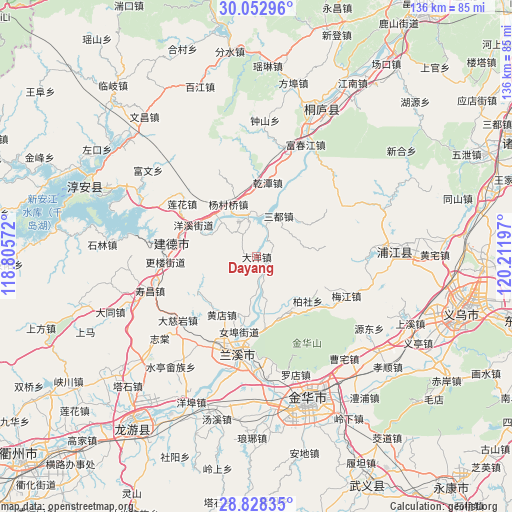
Dayang GPS coordinates[2]
29° 26' 33" North, 119° 30' 31.824" East
| Map corner | latitude | longitude |
|---|---|---|
| Upper-left | 30.05296°, | 118.80572° |
| Center: | 29.4425°, | 119.50884° |
| Lower-right: | 28.82835°, | 120.21197° |
| Map W x H: | 136.2×136.2 km | = 84.6×84.6mi |
| max Lat: | 53.31946° ⇑60.4% North |
| Dayang: | 29.4425° |
| min Lat: | ⇓39.6% South 18.22056° |
| min Long | Dayang | max Long |
| 75.07348° | 119.50884° | 134.28917° |
| W 78.8%⇐ | ⇒21.2% E |
Elevation
Elevation of Dayang is 36 m = 118 ft, and this is 448.8 m = 1472 ft below average elevation for this country.
| Max E: |
5622 m = 18445 ft | 75.3% |
| Avg. | 484.8 m = 1591 ft | |
| Dayang | 36 m = 118 ft | |
Min E: |
-3 m = -10 ft | 24.7% |
See also: China elevation on elevation.city.
Geographical zone
Dayang is located in North temperate zone (between Tropic of Cancer and the Arctic Circle). Distance of this Northern Tropic circle is 667.8 km =415 mi to South.| Distance of | km | miles | from Dayang |
|---|---|---|---|
| North Pole | 6733.4 | 4183.9 | to North |
| Arctic Circle | 4127.5 | 2564.7 | to North |
| Tropic Cancer | 667.8 | 415 | to South |
| Equator | 3273.7 | 2034.2 | to South |


Nearby cities:
15 places around Dayang: (largest is in red/bold)
• Baisha
26 km =16.2 mi,  125°
125°
• Baishe
17.8 km =11.1 mi, 129°
• Duntou
25.9 km =16.1 mi,  113°
113°
• Houren
22.4 km =13.9 mi,  210°
210°
• Lanjiang
25.7 km =16 mi,  190°
190°
• Lanxi
25.5 km =15.8 mi, 188°
• Meicheng
11.2 km =7 mi,  355°
355°
• Nübu
20.5 km =12.7 mi, 193°
• Qiantan
19.9 km =12.4 mi,  8°
8°
• Sandu
12 km =7.5 mi,  29°
29°
• Tangcun
26.7 km =16.6 mi,  229°
229°
• Xiabao
27.4 km =17 mi, 356°
• Xiachen
17.9 km =11.1 mi,  101°
101°
• Xiangxi
17.4 km =10.8 mi,  172°
172°
• Xin’anjiang
23.3 km =14.5 mi,  278°
278°
Sources, notices
• [Note1] Compared only with cities in China existing in our database
• [Src1] Map data: © OpenStreetMap contributors (CC-BY-SA)
• [Src2] Other city data from geonames.org with taken over terms of usage.
• [Src3] Geographical zone / Annual Mean Temperature by Robert A. Rohde @ Wikipedia
