Wenluo geodata
Wenluo (Hainan) is a seat of a fourth-order administrative division; located in China in Asia/Shanghai (GMT+8) time zone. In our database, there are 1268 cities with bigger population. Compared to other cities in China, 99.9% of cities are located further ↑North; 71.5% of cities are located further →East and 69.7% of cities have higher elevation than Wenluo. Note1


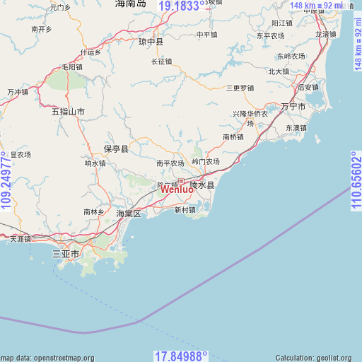
Wenluo GPS coordinates[2]
18° 31' 4.404" North, 109° 57' 10.404" East
| Map corner | latitude | longitude |
|---|---|---|
| Upper-left | 19.1833°, | 109.24977° |
| Center: | 18.51789°, | 109.95289° |
| Lower-right: | 17.84988°, | 110.65602° |
| Map W x H: | 148.3×148.3 km | = 92.1×92.1mi |
| max Lat: | 53.31946° ⇑99.9% North |
| Wenluo: | 18.51789° |
| min Lat: | ⇓0.1% South 18.22056° |
| min Long | Wenluo | max Long |
| 75.07348° | 109.95289° | 134.28917° |
| W 28.5%⇐ | ⇒71.5% E |
Elevation
Elevation of Wenluo is 53 m = 174 ft, and this is 431.8 m = 1417 ft below average elevation for this country.
| Max E: |
5622 m = 18445 ft | 69.7% |
| Avg. | 484.8 m = 1591 ft | |
| Wenluo | 53 m = 174 ft | |
Min E: |
-3 m = -10 ft | 30.3% |
See also: China elevation on elevation.city.
Geographical zone
Wenluo is located in North Torrid zone (between Equator and Tropic of Cancer). Distance of this Northern Tropic circle is 546.9 km =339.8 mi to North.| Distance of | km | miles | from Wenluo |
|---|---|---|---|
| North Pole | 7948.1 | 4938.7 | to North |
| Arctic Circle | 5342.2 | 3319.5 | to North |
| Tropic Cancer | 546.9 | 339.8 | to North |
| Equator | 2059 | 1279.4 | to South |


Nearby cities:
15 places around Wenluo: (largest is in red/bold)
• Baocheng
30 km =18.6 mi,  296°
296°
• Benhao
11.1 km =6.9 mi,  347°
347°
• Guangpo
11 km =6.8 mi,  70°
70°
• Haitangwan
24.9 km =15.5 mi,  239°
239°
• Jiamao
27.2 km =16.9 mi,  278°
278°
• Liugong
18.6 km =11.6 mi, 277°
• Li’an
15.3 km =9.5 mi,  128°
128°
• Longguang
5.8 km =3.6 mi,  256°
256°
• Nanqiao
26.5 km =16.5 mi,  48°
48°
• Qunying
15.4 km =9.6 mi,  306°
306°
• Shiling
24.5 km =15.2 mi, 311°
• Timeng
8.6 km =5.3 mi,  63°
63°
• Xincun
11.4 km =7.1 mi,  174°
174°
• Yelin
9.2 km =5.7 mi,  87°
87°
• Yingzhou
15.3 km =9.5 mi,  225°
225°
Sources, notices
• [Note1] Compared only with cities in China existing in our database
• [Src1] Map data: © OpenStreetMap contributors (CC-BY-SA)
• [Src2] Other city data from geonames.org with taken over terms of usage.
• [Src3] Geographical zone / Annual Mean Temperature by Robert A. Rohde @ Wikipedia
