Qunying geodata
Qunying (Hainan) is a seat of a fourth-order administrative division; located in China in Asia/Shanghai (GMT+8) time zone. In our database, there are 1268 cities with bigger population. Compared to other cities in China, 99.8% of cities are located further ↑North; 72.1% of cities are located further →East and 79.3% of cities have higher elevation than Qunying. Note1


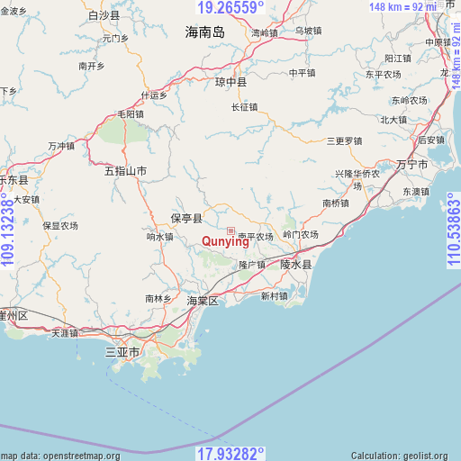
Qunying GPS coordinates[2]
18° 36' 1.836" North, 109° 50' 7.8" East
| Map corner | latitude | longitude |
|---|---|---|
| Upper-left | 19.26559°, | 109.13238° |
| Center: | 18.60051°, | 109.8355° |
| Lower-right: | 17.93282°, | 110.53863° |
| Map W x H: | 148.2×148.2 km | = 92.1×92.1mi |
| max Lat: | 53.31946° ⇑99.8% North |
| Qunying: | 18.60051° |
| min Lat: | ⇓0.2% South 18.22056° |
| min Long | Qunying | max Long |
| 75.07348° | 109.8355° | 134.28917° |
| W 27.9%⇐ | ⇒72.1% E |
Elevation
Elevation of Qunying is 28 m = 92 ft, and this is 456.8 m = 1499 ft below average elevation for this country.
| Max E: |
5622 m = 18445 ft | 79.3% |
| Avg. | 484.8 m = 1591 ft | |
| Qunying | 28 m = 92 ft | |
Min E: |
-3 m = -10 ft | 20.7% |
See also: China elevation on elevation.city.
Geographical zone
Qunying is located in North Torrid zone (between Equator and Tropic of Cancer). Distance of this Northern Tropic circle is 537.7 km =334.1 mi to North.| Distance of | km | miles | from Qunying |
|---|---|---|---|
| North Pole | 7938.9 | 4933 | to North |
| Arctic Circle | 5333 | 3313.8 | to North |
| Tropic Cancer | 537.7 | 334.1 | to North |
| Equator | 2068.2 | 1285.1 | to South |


Nearby cities:
15 places around Qunying: (largest is in red/bold)
• Baocheng
15 km =9.3 mi,  287°
287°
• Benhao
10.2 km =6.3 mi,  80°
80°
• Diaoluoshan
22 km =13.7 mi,  10°
10°
• Guangpo
23.4 km =14.5 mi,  103°
103°
• Jiamao
15.3 km =9.5 mi,  251°
251°
• Liugong
9.1 km =5.7 mi,  222°
222°
• Longguang
12.5 km =7.8 mi,  147°
147°
• Sandao
23.4 km =14.5 mi,  230°
230°
• Shiling
9.3 km =5.8 mi,  319°
319°
• Timeng
20.7 km =12.9 mi, 104°
• Wenluo
15.4 km =9.6 mi,  126°
126°
• Xiangshui
23.6 km =14.7 mi,  268°
268°
• Xinzheng
23.2 km =14.4 mi, 254°
• Yelin
23.3 km =14.5 mi,  112°
112°
• Yingzhou
20 km =12.4 mi,  175°
175°
Sources, notices
• [Note1] Compared only with cities in China existing in our database
• [Src1] Map data: © OpenStreetMap contributors (CC-BY-SA)
• [Src2] Other city data from geonames.org with taken over terms of usage.
• [Src3] Geographical zone / Annual Mean Temperature by Robert A. Rohde @ Wikipedia
