Baocheng geodata
Baocheng (Hainan) is a seat of a third-order administrative division; located in China in Asia/Shanghai (GMT+8) time zone. In our database, there are 1268 cities with bigger population. Compared to other cities in China, 99.8% of cities are located further ↑North; 72.8% of cities are located further →East and 69.5% of cities have higher elevation than Baocheng. Note1


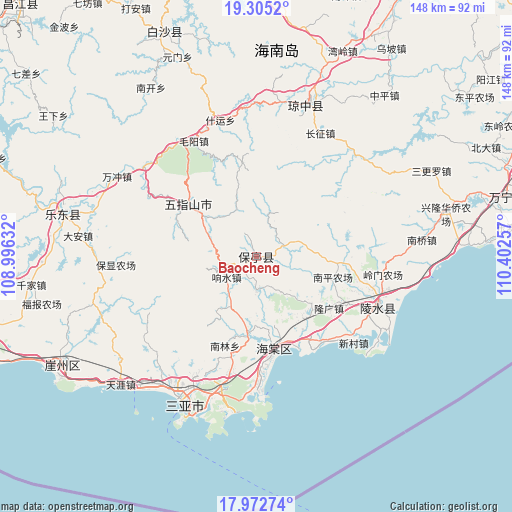
Baocheng GPS coordinates[2]
18° 38' 25.008" North, 109° 41' 57.984" East
| Map corner | latitude | longitude |
|---|---|---|
| Upper-left | 19.3052°, | 108.99632° |
| Center: | 18.64028°, | 109.69944° |
| Lower-right: | 17.97274°, | 110.40257° |
| Map W x H: | 148.2×148.2 km | = 92.1×92.1mi |
| max Lat: | 53.31946° ⇑99.8% North |
| Baocheng: | 18.64028° |
| min Lat: | ⇓0.2% South 18.22056° |
| min Long | Baocheng | max Long |
| 75.07348° | 109.69944° | 134.28917° |
| W 27.2%⇐ | ⇒72.8% E |
Elevation
Elevation of Baocheng is 54 m = 177 ft, and this is 430.8 m = 1413 ft below average elevation for this country.
| Max E: |
5622 m = 18445 ft | 69.5% |
| Avg. | 484.8 m = 1591 ft | |
| Baocheng | 54 m = 177 ft | |
Min E: |
-3 m = -10 ft | 30.5% |
See also: China elevation on elevation.city.
Geographical zone
Baocheng is located in North Torrid zone (between Equator and Tropic of Cancer). Distance of this Northern Tropic circle is 533.3 km =331.4 mi to North.| Distance of | km | miles | from Baocheng |
|---|---|---|---|
| North Pole | 7934.5 | 4930.3 | to North |
| Arctic Circle | 5328.6 | 3311 | to North |
| Tropic Cancer | 533.3 | 331.4 | to North |
| Equator | 2072.6 | 1287.9 | to South |


Nearby cities:
15 places around Baocheng: (largest is in red/bold)
• Benhao
24.5 km =15.2 mi,  96°
96°
• Changhao
25.7 km =16 mi,  294°
294°
• Chongshan
26.2 km =16.3 mi,  307°
307°
• Diaoluoshan
25.2 km =15.7 mi,  46°
46°
• Haitangwan
26.9 km =16.7 mi,  168°
168°
• Jiamao
9.3 km =5.8 mi,  181°
181°
• Liugong
13.9 km =8.6 mi,  143°
143°
• Longguang
25.9 km =16.1 mi,  125°
125°
• Nanlin
27 km =16.8 mi,  200°
200°
• Nansheng
14.5 km =9 mi, 311°
• Qunying
15 km =9.3 mi,  107°
107°
• Sandao
19.6 km =12.2 mi,  190°
190°
• Shiling
8.8 km =5.5 mi,  72°
72°
• Xiangshui
10.6 km =6.6 mi,  240°
240°
• Xinzheng
13.5 km =8.4 mi,  216°
216°
Sources, notices
• [Note1] Compared only with cities in China existing in our database
• [Src1] Map data: © OpenStreetMap contributors (CC-BY-SA)
• [Src2] Other city data from geonames.org with taken over terms of usage.
• [Src3] Geographical zone / Annual Mean Temperature by Robert A. Rohde @ Wikipedia
