Tanxi geodata
Tanxi (Zhejiang) is a seat of a fourth-order administrative division; located in China in Asia/Shanghai (GMT+8) time zone. In our database, there are 1268 cities with bigger population. Compared to other cities in China, 58.3% of cities are located further ↑North; 81.5% of cities are located further ←West and 53.7% of cities have lower elevation than Tanxi. Note1


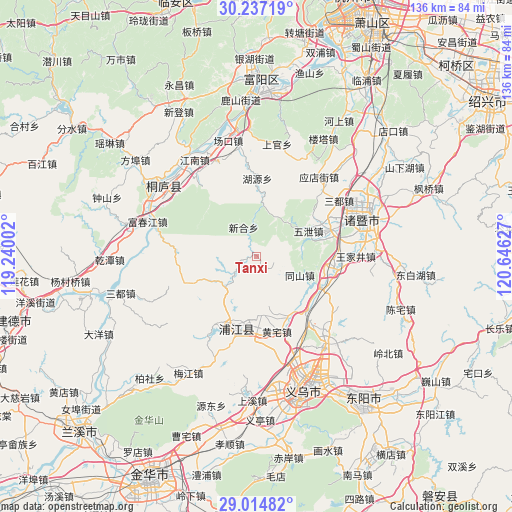
Tanxi GPS coordinates[2]
29° 37' 40.296" North, 119° 56' 35.304" East
| Map corner | latitude | longitude |
|---|---|---|
| Upper-left | 30.23719°, | 119.24002° |
| Center: | 29.62786°, | 119.94314° |
| Lower-right: | 29.01482°, | 120.64627° |
| Map W x H: | 135.9×135.9 km | = 84.4×84.4mi |
| max Lat: | 53.31946° ⇑58.3% North |
| Tanxi: | 29.62786° |
| min Lat: | ⇓41.7% South 18.22056° |
| min Long | Tanxi | max Long |
| 75.07348° | 119.94314° | 134.28917° |
| W 81.5%⇐ | ⇒18.5% E |
Elevation
Elevation of Tanxi is 195 m = 640 ft, and this is 289.8 m = 951 ft below average elevation for this country.
| Max E: |
5622 m = 18445 ft | 46.3% |
| Avg. | 484.8 m = 1591 ft | |
| Tanxi | 195 m = 640 ft | |
Min E: |
-3 m = -10 ft | 53.7% |
See also: China elevation on elevation.city.
Geographical zone
Tanxi is located in North temperate zone (between Tropic of Cancer and the Arctic Circle). Distance of this Northern Tropic circle is 688.4 km =427.8 mi to South.| Distance of | km | miles | from Tanxi |
|---|---|---|---|
| North Pole | 6712.8 | 4171.1 | to North |
| Arctic Circle | 4106.9 | 2551.9 | to North |
| Tropic Cancer | 688.4 | 427.8 | to South |
| Equator | 3294.3 | 2047 | to South |


Nearby cities:
15 places around Tanxi: (largest is in red/bold)
• Anhua
18.2 km =11.3 mi,  115°
115°
• Caota
19.4 km =12.1 mi,  71°
71°
• Dachen
26.3 km =16.3 mi,  137°
137°
• Datang’an
22.5 km =14 mi, 71°
• Fengchuan
26 km =16.2 mi,  321°
321°
• Gaochengtou
12.5 km =7.8 mi,  113°
113°
• Huangzhai
20.6 km =12.8 mi,  165°
165°
• Huyuan
20.6 km =12.8 mi,  0°
0°
• Paitou
20.2 km =12.6 mi,  96°
96°
• Puyang
19.7 km =12.2 mi,  195°
195°
• Shixiang
15.2 km =9.4 mi,  64°
64°
• Wangjiajing
26.2 km =16.3 mi,  90°
90°
• Xinhe
8.4 km =5.2 mi,  335°
335°
• Yantou
15.3 km =9.5 mi,  175°
175°
• Yuzhai
9.9 km =6.2 mi,  226°
226°
Sources, notices
• [Note1] Compared only with cities in China existing in our database
• [Src1] Map data: © OpenStreetMap contributors (CC-BY-SA)
• [Src2] Other city data from geonames.org with taken over terms of usage.
• [Src3] Geographical zone / Annual Mean Temperature by Robert A. Rohde @ Wikipedia
