Ruanshi geodata
Ruanshi (Zhejiang) is a seat of a fourth-order administrative division; located in China in Asia/Shanghai (GMT+8) time zone. In our database, there are 1268 cities with bigger population. Compared to other cities in China, 55.4% of cities are located further ↑North; 84.4% of cities are located further ←West and 53.8% of cities have higher elevation than Ruanshi. Note1


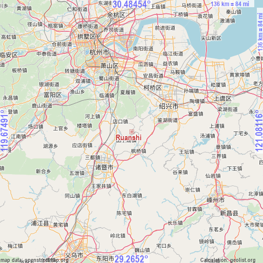
Ruanshi GPS coordinates[2]
29° 52' 36.228" North, 120° 22' 40.908" East
| Map corner | latitude | longitude |
|---|---|---|
| Upper-left | 30.48454°, | 119.67491° |
| Center: | 29.87673°, | 120.37803° |
| Lower-right: | 29.2652°, | 121.08116° |
| Map W x H: | 135.6×135.6 km | = 84.3×84.3mi |
| max Lat: | 53.31946° ⇑55.4% North |
| Ruanshi: | 29.87673° |
| min Lat: | ⇓44.6% South 18.22056° |
| min Long | Ruanshi | max Long |
| 75.07348° | 120.37803° | 134.28917° |
| W 84.4%⇐ | ⇒15.6% E |
Elevation
Elevation of Ruanshi is 138 m = 453 ft, and this is 346.8 m = 1138 ft below average elevation for this country.
| Max E: |
5622 m = 18445 ft | 53.8% |
| Avg. | 484.8 m = 1591 ft | |
| Ruanshi | 138 m = 453 ft | |
Min E: |
-3 m = -10 ft | 46.2% |
See also: China elevation on elevation.city.
Geographical zone
Ruanshi is located in North temperate zone (between Tropic of Cancer and the Arctic Circle). Distance of this Northern Tropic circle is 716.1 km =445 mi to South.| Distance of | km | miles | from Ruanshi |
|---|---|---|---|
| North Pole | 6685.1 | 4153.9 | to North |
| Arctic Circle | 4079.2 | 2534.7 | to North |
| Tropic Cancer | 716.1 | 445 | to South |
| Equator | 3322 | 2064.2 | to South |


Nearby cities:
15 places around Ruanshi: (largest is in red/bold)
• Chengnan
21.1 km =13.1 mi,  59°
59°
• Diankou
7.5 km =4.7 mi,  339°
339°
• Fengqiao
10.2 km =6.3 mi,  159°
159°
• Fushan
22.1 km =13.7 mi,  52°
52°
• Jiangzao
7.2 km =4.5 mi,  236°
236°
• Jianhu
21.9 km =13.6 mi, 58°
• Jinhua
17.5 km =10.9 mi,  330°
330°
• Jinsanjiao
19.1 km =11.9 mi, 48°
• Lizhu
12.2 km =7.6 mi,  44°
44°
• Puyang
17.5 km =10.9 mi,  314°
314°
• Shanxiahu
3.3 km =2.1 mi,  227°
227°
• Xialu
21.1 km =13.1 mi,  354°
354°
• Zhaojia
15.4 km =9.6 mi,  150°
150°
• Zhibu
14 km =8.7 mi, 243°
• Zhuji
21.9 km =13.6 mi,  216°
216°
Sources, notices
• [Note1] Compared only with cities in China existing in our database
• [Src1] Map data: © OpenStreetMap contributors (CC-BY-SA)
• [Src2] Other city data from geonames.org with taken over terms of usage.
• [Src3] Geographical zone / Annual Mean Temperature by Robert A. Rohde @ Wikipedia
