Jinhua geodata
Jinhua (Zhejiang) is a seat of a fourth-order administrative division; located in China in Asia/Shanghai (GMT+8) time zone. In our database, there are 1268 cities with bigger population. Compared to other cities in China, 53.9% of cities are located further ↑North; 83.8% of cities are located further ←West and 92.7% of cities have higher elevation than Jinhua. Note1


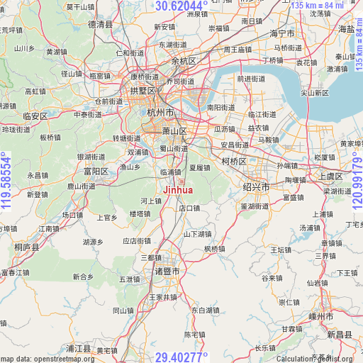
Jinhua GPS coordinates[2]
30° 0' 48.492" North, 120° 17' 19.176" East
| Map corner | latitude | longitude |
|---|---|---|
| Upper-left | 30.62044°, | 119.58554° |
| Center: | 30.01347°, | 120.28866° |
| Lower-right: | 29.40277°, | 120.99179° |
| Map W x H: | 135.4×135.4 km | = 84.1×84.1mi |
| max Lat: | 53.31946° ⇑53.9% North |
| Jinhua: | 30.01347° |
| min Lat: | ⇓46.1% South 18.22056° |
| min Long | Jinhua | max Long |
| 75.07348° | 120.28866° | 134.28917° |
| W 83.8%⇐ | ⇒16.2% E |
Elevation
Elevation of Jinhua is 8 m = 26 ft, and this is 476.8 m = 1564 ft below average elevation for this country.
| Max E: |
5622 m = 18445 ft | 92.7% |
| Avg. | 484.8 m = 1591 ft | |
| Jinhua | 8 m = 26 ft | |
Min E: |
-3 m = -10 ft | 7.3% |
See also: China elevation on elevation.city.
Geographical zone
Jinhua is located in North temperate zone (between Tropic of Cancer and the Arctic Circle). Distance of this Northern Tropic circle is 731.3 km =454.4 mi to South.| Distance of | km | miles | from Jinhua |
|---|---|---|---|
| North Pole | 6669.9 | 4144.5 | to North |
| Arctic Circle | 4064 | 2525.3 | to North |
| Tropic Cancer | 731.3 | 454.4 | to South |
| Equator | 3337.2 | 2073.6 | to South |


Nearby cities:
15 places around Jinhua: (largest is in red/bold)
• Daicun
8.9 km =5.5 mi,  272°
272°
• Diankou
10.1 km =6.3 mi,  143°
143°
• Heshang
14.6 km =9.1 mi,  237°
237°
• Hutang
14.5 km =9 mi,  61°
61°
• Linpu
5.4 km =3.4 mi,  308°
308°
• Puyang
4.8 km =3 mi,  233°
233°
• Qianqing
16.7 km =10.4 mi,  42°
42°
• Ruanshi
17.5 km =10.9 mi,  150°
150°
• Suoqian
11.2 km =7 mi,  354°
354°
• Wenyan
17 km =10.6 mi,  318°
318°
• Xialu
8.7 km =5.4 mi,  47°
47°
• Xiaoshan
17.4 km =10.8 mi, 350°
• Xintang
15.3 km =9.5 mi,  5°
5°
• Yangxunqiao
15.8 km =9.8 mi,  24°
24°
• Yiqiao
10.7 km =6.6 mi, 305°
Sources, notices
• [Note1] Compared only with cities in China existing in our database
• [Src1] Map data: © OpenStreetMap contributors (CC-BY-SA)
• [Src2] Other city data from geonames.org with taken over terms of usage.
• [Src3] Geographical zone / Annual Mean Temperature by Robert A. Rohde @ Wikipedia
