Lianghu geodata
Lianghu (Zhejiang) is a seat of a fourth-order administrative division; located in China in Asia/Shanghai (GMT+8) time zone. With population of 155,000 people, there are 279 cities with bigger population in this country. Compared to other cities in China, 54.1% of cities are located further ↑North; 87.3% of cities are located further ←West and 82.1% of cities have higher elevation than Lianghu. Note1


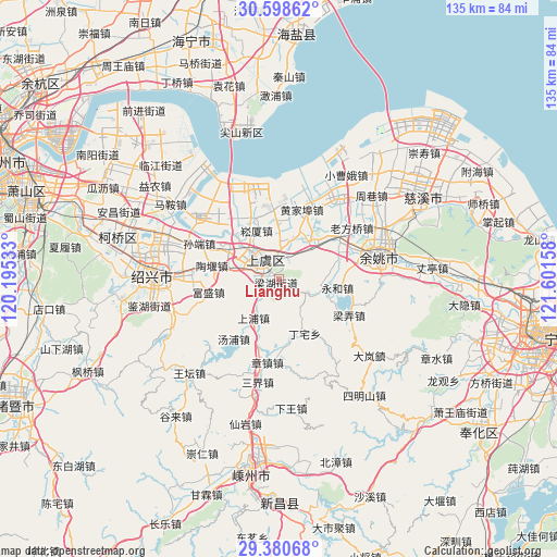
Lianghu GPS coordinates[2]
29° 59' 29.472" North, 120° 53' 54.42" East
| Map corner | latitude | longitude |
|---|---|---|
| Upper-left | 30.59862°, | 120.19533° |
| Center: | 29.99152°, | 120.89845° |
| Lower-right: | 29.38068°, | 121.60158° |
| Map W x H: | 135.4×135.4 km | = 84.1×84.1mi |
| max Lat: | 53.31946° ⇑54.1% North |
| Lianghu: | 29.99152° |
| min Lat: | ⇓45.9% South 18.22056° |
| min Long | Lianghu | max Long |
| 75.07348° | 120.89845° | 134.28917° |
| W 87.3%⇐ | ⇒12.7% E |
Elevation
Elevation of Lianghu is 22 m = 72 ft, and this is 462.8 m = 1518 ft below average elevation for this country.
| Max E: |
5622 m = 18445 ft | 82.1% |
| Avg. | 484.8 m = 1591 ft | |
| Lianghu | 22 m = 72 ft | |
Min E: |
-3 m = -10 ft | 17.9% |
See also: Lianghu elevation on elevation.city.
Geographical zone
Lianghu is located in North temperate zone (between Tropic of Cancer and the Arctic Circle). Distance of this Northern Tropic circle is 728.8 km =452.9 mi to South.| Distance of | km | miles | from Lianghu |
|---|---|---|---|
| North Pole | 6672.3 | 4146 | to North |
| Arctic Circle | 4066.4 | 2526.7 | to North |
| Tropic Cancer | 728.8 | 452.9 | to South |
| Equator | 3334.7 | 2072.1 | to South |


Nearby cities:
15 places around Lianghu: (largest is in red/bold)
• Changtang
11 km =6.8 mi,  248°
248°
• Daoxu
14 km =8.7 mi,  295°
295°
• Dongguan
8.4 km =5.2 mi,  285°
285°
• Fenghui
8.9 km =5.5 mi,  121°
121°
• Gaibei
16.6 km =10.3 mi,  356°
356°
• Haoba
6.3 km =3.9 mi,  230°
230°
• Mazhu
17.2 km =10.7 mi,  56°
56°
• Moushan
12.8 km =8 mi,  43°
43°
• Shangpu
11.4 km =7.1 mi,  214°
214°
• Shangyu
3.8 km =2.4 mi,  315°
315°
• Songxia
13 km =8.1 mi,  334°
334°
• Taoyan
16.7 km =10.4 mi,  281°
281°
• Xiaoyue
9.3 km =5.8 mi,  17°
17°
• Xietang
14.5 km =9 mi,  1°
1°
• Yongheshi
14.3 km =8.9 mi,  98°
98°
Sources, notices
• [Note1] Compared only with cities in China existing in our database
• [Src1] Map data: © OpenStreetMap contributors (CC-BY-SA)
• [Src2] Other city data from geonames.org with taken over terms of usage.
• [Src3] Geographical zone / Annual Mean Temperature by Robert A. Rohde @ Wikipedia
