Moushan geodata
Moushan (Zhejiang) is a seat of a fourth-order administrative division; located in China in Asia/Shanghai (GMT+8) time zone. In our database, there are 1268 cities with bigger population. Compared to other cities in China, 53.2% of cities are located further ↑North; 87.7% of cities are located further ←West and 89.9% of cities have higher elevation than Moushan. Note1


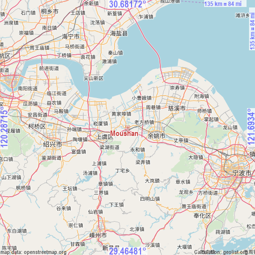
Moushan GPS coordinates[2]
30° 4' 30.504" North, 120° 59' 24.972" East
| Map corner | latitude | longitude |
|---|---|---|
| Upper-left | 30.68172°, | 120.28715° |
| Center: | 30.07514°, | 120.99027° |
| Lower-right: | 29.46481°, | 121.6934° |
| Map W x H: | 135.3×135.3 km | = 84.1×84.1mi |
| max Lat: | 53.31946° ⇑53.2% North |
| Moushan: | 30.07514° |
| min Lat: | ⇓46.8% South 18.22056° |
| min Long | Moushan | max Long |
| 75.07348° | 120.99027° | 134.28917° |
| W 87.7%⇐ | ⇒12.3% E |
Elevation
Elevation of Moushan is 10 m = 33 ft, and this is 474.8 m = 1558 ft below average elevation for this country.
| Max E: |
5622 m = 18445 ft | 89.9% |
| Avg. | 484.8 m = 1591 ft | |
| Moushan | 10 m = 33 ft | |
Min E: |
-3 m = -10 ft | 10.1% |
See also: China elevation on elevation.city.
Geographical zone
Moushan is located in North temperate zone (between Tropic of Cancer and the Arctic Circle). Distance of this Northern Tropic circle is 738.1 km =458.6 mi to South.| Distance of | km | miles | from Moushan |
|---|---|---|---|
| North Pole | 6663 | 4140.2 | to North |
| Arctic Circle | 4057.1 | 2521 | to North |
| Tropic Cancer | 738.1 | 458.6 | to South |
| Equator | 3344 | 2077.9 | to South |


Nearby cities:
15 places around Moushan: (largest is in red/bold)
• Fenghui
14.1 km =8.8 mi,  185°
185°
• Gaibei
12.2 km =7.6 mi,  306°
306°
• Huangjiabu
8.3 km =5.2 mi,  336°
336°
• Langxia
13.1 km =8.1 mi,  38°
38°
• Lianghu
12.8 km =8 mi,  223°
223°
• Linshan
8.8 km =5.5 mi,  0°
0°
• Mazhu
5.5 km =3.4 mi,  86°
86°
• Shangyu
13.2 km =8.2 mi,  239°
239°
• Simen
10.7 km =6.6 mi,  25°
25°
• Songxia
14.6 km =9.1 mi,  279°
279°
• Xiaodong
11.5 km =7.1 mi,  113°
113°
• Xiaoyue
6 km =3.7 mi,  265°
265°
• Xietang
10 km =6.2 mi,  301°
301°
• Yongheshi
12.6 km =7.8 mi,  155°
155°
• Yuyao
15.6 km =9.7 mi,  100°
100°
Sources, notices
• [Note1] Compared only with cities in China existing in our database
• [Src1] Map data: © OpenStreetMap contributors (CC-BY-SA)
• [Src2] Other city data from geonames.org with taken over terms of usage.
• [Src3] Geographical zone / Annual Mean Temperature by Robert A. Rohde @ Wikipedia
