Lanfang geodata
Lanfang (Guangdong) is a seat of a fourth-order administrative division; located in China in Asia/Shanghai (GMT+8) time zone. In our database, there are 1268 cities with bigger population. Compared to other cities in China, 87.9% of cities are located further ↑North; 61.3% of cities are located further ←West and 59.2% of cities have lower elevation than Lanfang. Note1


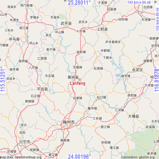
Lanfang GPS coordinates[2]
24° 38' 33.612" North, 116° 12' 56.268" East
| Map corner | latitude | longitude |
|---|---|---|
| Upper-left | 25.28011°, | 115.51251° |
| Center: | 24.64267°, | 116.21563° |
| Lower-right: | 24.00196°, | 116.91876° |
| Map W x H: | 142.1×142.1 km | = 88.3×88.3mi |
| max Lat: | 53.31946° ⇑87.9% North |
| Lanfang: | 24.64267° |
| min Lat: | ⇓12.1% South 18.22056° |
| min Long | Lanfang | max Long |
| 75.07348° | 116.21563° | 134.28917° |
| W 61.3%⇐ | ⇒38.7% E |
Elevation
Elevation of Lanfang is 249 m = 817 ft, and this is 235.8 m = 774 ft below average elevation for this country.
| Max E: |
5622 m = 18445 ft | 40.8% |
| Avg. | 484.8 m = 1591 ft | |
| Lanfang | 249 m = 817 ft | |
Min E: |
-3 m = -10 ft | 59.2% |
See also: China elevation on elevation.city.
Geographical zone
Lanfang is located in North temperate zone (between Tropic of Cancer and the Arctic Circle). Distance of this Northern Tropic circle is 134.1 km =83.3 mi to South.| Distance of | km | miles | from Lanfang |
|---|---|---|---|
| North Pole | 7267.1 | 4515.6 | to North |
| Arctic Circle | 4661.2 | 2896.3 | to North |
| Tropic Cancer | 134.1 | 83.3 | to South |
| Equator | 2740 | 1702.6 | to South |


Nearby cities:
15 places around Lanfang: (largest is in red/bold)
• Baidu
16.7 km =10.4 mi,  188°
188°
• Beiqi
21.7 km =13.5 mi,  41°
41°
• Changtan
7.4 km =4.6 mi,  300°
300°
• Guangfu
21.1 km =13.1 mi,  350°
350°
• Jiaocheng
5.2 km =3.2 mi,  288°
288°
• Longwen
14.3 km =8.9 mi,  111°
111°
• Maoping
23.5 km =14.6 mi,  271°
271°
• Nanqi
13.5 km =8.4 mi,  47°
47°
• Sanzhen
10.5 km =6.5 mi,  237°
237°
• Sishui
22.8 km =14.2 mi, 302°
• Songyuan
19.6 km =12.2 mi,  58°
58°
• Taoyao
22.4 km =13.9 mi,  91°
91°
• Wenfu
11.7 km =7.3 mi, 349°
• Xinbu
17.2 km =10.7 mi,  212°
212°
• Xingfu
4.5 km =2.8 mi,  280°
280°
Sources, notices
• [Note1] Compared only with cities in China existing in our database
• [Src1] Map data: © OpenStreetMap contributors (CC-BY-SA)
• [Src2] Other city data from geonames.org with taken over terms of usage.
• [Src3] Geographical zone / Annual Mean Temperature by Robert A. Rohde @ Wikipedia
