Xinbu geodata
Xinbu (Guangdong) is a seat of a fourth-order administrative division; located in China in Asia/Shanghai (GMT+8) time zone. In our database, there are 1268 cities with bigger population. Compared to other cities in China, 88.4% of cities are located further ↑North; 60.8% of cities are located further ←West and 55.1% of cities have higher elevation than Xinbu. Note1


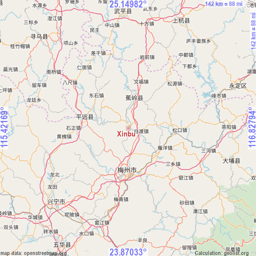
Xinbu GPS coordinates[2]
24° 30' 42.12" North, 116° 7' 29.316" East
| Map corner | latitude | longitude |
|---|---|---|
| Upper-left | 25.14982°, | 115.42169° |
| Center: | 24.5117°, | 116.12481° |
| Lower-right: | 23.87033°, | 116.82794° |
| Map W x H: | 142.3×142.3 km | = 88.4×88.4mi |
| max Lat: | 53.31946° ⇑88.4% North |
| Xinbu: | 24.5117° |
| min Lat: | ⇓11.6% South 18.22056° |
| min Long | Xinbu | max Long |
| 75.07348° | 116.12481° | 134.28917° |
| W 60.8%⇐ | ⇒39.2% E |
Elevation
Elevation of Xinbu is 131 m = 430 ft, and this is 353.8 m = 1161 ft below average elevation for this country.
| Max E: |
5622 m = 18445 ft | 55.1% |
| Avg. | 484.8 m = 1591 ft | |
| Xinbu | 131 m = 430 ft | |
Min E: |
-3 m = -10 ft | 44.9% |
See also: China elevation on elevation.city.
Geographical zone
Xinbu is located in North temperate zone (between Tropic of Cancer and the Arctic Circle). Distance of this Northern Tropic circle is 119.5 km =74.3 mi to South.| Distance of | km | miles | from Xinbu |
|---|---|---|---|
| North Pole | 7281.6 | 4524.6 | to North |
| Arctic Circle | 4675.7 | 2905.3 | to North |
| Tropic Cancer | 119.5 | 74.3 | to South |
| Equator | 2725.4 | 1693.5 | to South |


Nearby cities:
15 places around Xinbu: (largest is in red/bold)
• Baidu
7.1 km =4.4 mi,  105°
105°
• Batou
22.3 km =13.9 mi,  300°
300°
• Bingcun
22.1 km =13.7 mi,  136°
136°
• Changtan
18.6 km =11.6 mi,  8°
8°
• Changtian
16.8 km =10.4 mi,  253°
253°
• Chengbei
20.6 km =12.8 mi,  187°
187°
• Chengdong
14.9 km =9.3 mi,  174°
174°
• Jiaocheng
16.7 km =10.4 mi, 14°
• Lanfang
17.2 km =10.7 mi,  32°
32°
• Maoping
20.8 km =12.9 mi,  316°
316°
• Rezhe
14.8 km =9.2 mi,  280°
280°
• Sanzhen
8.9 km =5.5 mi,  2°
2°
• Shishan
8.1 km =5 mi,  208°
208°
• Xijiao
22 km =13.7 mi, 186°
• Xingfu
16.1 km =10 mi,  17°
17°
Sources, notices
• [Note1] Compared only with cities in China existing in our database
• [Src1] Map data: © OpenStreetMap contributors (CC-BY-SA)
• [Src2] Other city data from geonames.org with taken over terms of usage.
• [Src3] Geographical zone / Annual Mean Temperature by Robert A. Rohde @ Wikipedia
