Qingxi geodata
Qingxi (Guangdong) is a seat of a fourth-order administrative division; located in China in Asia/Shanghai (GMT+8) time zone. In our database, there are 1268 cities with bigger population. Compared to other cities in China, 88.4% of cities are located further ↑North; 63.6% of cities are located further ←West and 64.3% of cities have higher elevation than Qingxi. Note1


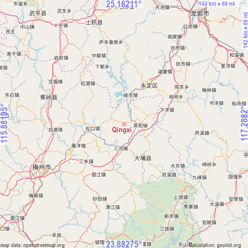
Qingxi GPS coordinates[2]
24° 31' 26.616" North, 116° 35' 6.252" East
| Map corner | latitude | longitude |
|---|---|---|
| Upper-left | 25.16211°, | 115.88195° |
| Center: | 24.52406°, | 116.58507° |
| Lower-right: | 23.88275°, | 117.2882° |
| Map W x H: | 142.3×142.3 km | = 88.4×88.4mi |
| max Lat: | 53.31946° ⇑88.4% North |
| Qingxi: | 24.52406° |
| min Lat: | ⇓11.6% South 18.22056° |
| min Long | Qingxi | max Long |
| 75.07348° | 116.58507° | 134.28917° |
| W 63.6%⇐ | ⇒36.4% E |
Elevation
Elevation of Qingxi is 76 m = 249 ft, and this is 408.8 m = 1341 ft below average elevation for this country.
| Max E: |
5622 m = 18445 ft | 64.3% |
| Avg. | 484.8 m = 1591 ft | |
| Qingxi | 76 m = 249 ft | |
Min E: |
-3 m = -10 ft | 35.7% |
See also: China elevation on elevation.city.
Geographical zone
Qingxi is located in North temperate zone (between Tropic of Cancer and the Arctic Circle). Distance of this Northern Tropic circle is 120.9 km =75.1 mi to South.| Distance of | km | miles | from Qingxi |
|---|---|---|---|
| North Pole | 7280.2 | 4523.7 | to North |
| Arctic Circle | 4674.4 | 2904.5 | to North |
| Tropic Cancer | 120.9 | 75.1 | to South |
| Equator | 2726.8 | 1694.4 | to South |


Nearby cities:
15 places around Qingxi: (largest is in red/bold)
• Chayang
9.3 km =5.8 mi,  93°
93°
• Chengjiao
26 km =16.2 mi,  31°
31°
• Dama
20.8 km =12.9 mi,  195°
195°
• Fengshi
17.5 km =10.9 mi,  12°
12°
• Hongshan
25.7 km =16 mi,  344°
344°
• Huliao
21.2 km =13.2 mi,  150°
150°
• Longwen
25.3 km =15.7 mi,  288°
288°
• Sanhe
13.8 km =8.6 mi,  187°
187°
• Songdong
12.6 km =7.8 mi,  272°
272°
• Songkou
18.1 km =11.2 mi,  262°
262°
• Songnan
17.3 km =10.7 mi, 260°
• Taoyao
19.4 km =12.1 mi,  309°
309°
• Xihe
17 km =10.6 mi,  104°
104°
• Yanshang
24.6 km =15.3 mi,  113°
113°
• Yingya
18.7 km =11.6 mi,  213°
213°
Sources, notices
• [Note1] Compared only with cities in China existing in our database
• [Src1] Map data: © OpenStreetMap contributors (CC-BY-SA)
• [Src2] Other city data from geonames.org with taken over terms of usage.
• [Src3] Geographical zone / Annual Mean Temperature by Robert A. Rohde @ Wikipedia
