Yingya geodata
Yingya (Guangdong) is a seat of a fourth-order administrative division; located in China in Asia/Shanghai (GMT+8) time zone. In our database, there are 1268 cities with bigger population. Compared to other cities in China, 88.9% of cities are located further ↑North; 63% of cities are located further ←West and 54.3% of cities have lower elevation than Yingya. Note1


Yingya GPS coordinates[2]
24° 23' 2.76" North, 116° 28' 55.38" East
| Map corner | latitude | longitude |
|---|---|---|
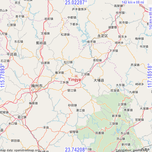
| Upper-left | 25.02287°, | 115.77893° |
| Center: | 24.3841°, | 116.48205° |
| Lower-right: | 23.74208°, | 117.18518° |
| Map W x H: | 142.4×142.4 km | = 88.5×88.5mi |
| max Lat: | 53.31946° ⇑88.9% North |
| Yingya: | 24.3841° |
| min Lat: | ⇓11.1% South 18.22056° |
| min Long | Yingya | max Long |
| 75.07348° | 116.48205° | 134.28917° |
| W 63%⇐ | ⇒37% E |
Elevation
Elevation of Yingya is 200 m = 656 ft, and this is 284.8 m = 934 ft below average elevation for this country.
| Max E: |
5622 m = 18445 ft | 45.7% |
| Avg. | 484.8 m = 1591 ft | |
| Yingya | 200 m = 656 ft | |
Min E: |
-3 m = -10 ft | 54.3% |
See also: China elevation on elevation.city.
Geographical zone
Yingya is located in North temperate zone (between Tropic of Cancer and the Arctic Circle). Distance of this Northern Tropic circle is 105.3 km =65.4 mi to South.| Distance of | km | miles | from Yingya |
|---|---|---|---|
| North Pole | 7295.8 | 4533.4 | to North |
| Arctic Circle | 4689.9 | 2914.2 | to North |
| Tropic Cancer | 105.3 | 65.4 | to South |
| Equator | 2711.3 | 1684.7 | to South |


Nearby cities:
15 places around Yingya: (largest is in red/bold)
• Bingcun
21.2 km =13.2 mi,  264°
264°
• Chayang
24.8 km =15.4 mi,  52°
52°
• Dama
6.6 km =4.1 mi,  133°
133°
• Gaopi
26.3 km =16.3 mi,  144°
144°
• Guye
25.5 km =15.8 mi,  146°
146°
• Huliao
20.9 km =13 mi,  98°
98°
• Qingxi
18.7 km =11.6 mi,  33°
33°
• Sanhe
8.8 km =5.5 mi,  77°
77°
• Sanxiang
12.6 km =7.8 mi,  243°
243°
• Songdong
16.4 km =10.2 mi,  352°
352°
• Songkou
15.1 km =9.4 mi,  330°
330°
• Songnan
14.3 km =8.9 mi, 332°
• Yanyang
16.6 km =10.3 mi,  282°
282°
• Yinjiang
13.7 km =8.5 mi,  197°
197°
• Zhourui
21.3 km =13.2 mi,  160°
160°
Sources, notices
• [Note1] Compared only with cities in China existing in our database
• [Src1] Map data: © OpenStreetMap contributors (CC-BY-SA)
• [Src2] Other city data from geonames.org with taken over terms of usage.
• [Src3] Geographical zone / Annual Mean Temperature by Robert A. Rohde @ Wikipedia
