Songkou geodata
Songkou (Guangdong) is a seat of a fourth-order administrative division; located in China in Asia/Shanghai (GMT+8) time zone. In our database, there are 1268 cities with bigger population. Compared to other cities in China, 88.5% of cities are located further ↑North; 62.5% of cities are located further ←West and 67.2% of cities have higher elevation than Songkou. Note1


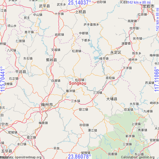
Songkou GPS coordinates[2]
24° 30' 7.92" North, 116° 24' 27.108" East
| Map corner | latitude | longitude |
|---|---|---|
| Upper-left | 25.14037°, | 115.70441° |
| Center: | 24.5022°, | 116.40753° |
| Lower-right: | 23.86078°, | 117.11066° |
| Map W x H: | 142.3×142.3 km | = 88.4×88.4mi |
| max Lat: | 53.31946° ⇑88.5% North |
| Songkou: | 24.5022° |
| min Lat: | ⇓11.5% South 18.22056° |
| min Long | Songkou | max Long |
| 75.07348° | 116.40753° | 134.28917° |
| W 62.5%⇐ | ⇒37.5% E |
Elevation
Elevation of Songkou is 64 m = 210 ft, and this is 420.8 m = 1381 ft below average elevation for this country.
| Max E: |
5622 m = 18445 ft | 67.2% |
| Avg. | 484.8 m = 1591 ft | |
| Songkou | 64 m = 210 ft | |
Min E: |
-3 m = -10 ft | 32.8% |
See also: China elevation on elevation.city.
Geographical zone
Songkou is located in North temperate zone (between Tropic of Cancer and the Arctic Circle). Distance of this Northern Tropic circle is 118.5 km =73.6 mi to South.| Distance of | km | miles | from Songkou |
|---|---|---|---|
| North Pole | 7282.7 | 4525.3 | to North |
| Arctic Circle | 4676.8 | 2906 | to North |
| Tropic Cancer | 118.5 | 73.6 | to South |
| Equator | 2724.4 | 1692.9 | to South |


Nearby cities:
15 places around Songkou: (largest is in red/bold)
• Baidu
21.8 km =13.5 mi,  267°
267°
• Bingcun
20.2 km =12.6 mi,  221°
221°
• Dama
21.5 km =13.4 mi,  144°
144°
• Lanfang
24.9 km =15.5 mi,  308°
308°
• Longwen
12 km =7.5 mi,  329°
329°
• Qingxi
18.1 km =11.2 mi,  82°
82°
• Sanhe
19.7 km =12.2 mi,  124°
124°
• Sanxiang
19.1 km =11.9 mi,  191°
191°
• Songdong
6.2 km =3.9 mi,  60°
60°
• Songnan
1 km =0.6 mi, 119°
• Songyuan
26.1 km =16.2 mi,  353°
353°
• Taoyao
15.2 km =9.4 mi,  11°
11°
• Yanyang
12.9 km =8 mi, 222°
• Yingya
15.1 km =9.4 mi,  150°
150°
• Yinjiang
26.5 km =16.5 mi,  172°
172°
Sources, notices
• [Note1] Compared only with cities in China existing in our database
• [Src1] Map data: © OpenStreetMap contributors (CC-BY-SA)
• [Src2] Other city data from geonames.org with taken over terms of usage.
• [Src3] Geographical zone / Annual Mean Temperature by Robert A. Rohde @ Wikipedia
