Yenan geodata
Yenan (Guangdong) is a seat of a fourth-order administrative division; located in China in Asia/Shanghai (GMT+8) time zone. In our database, there are 1268 cities with bigger population. Compared to other cities in China, 89.7% of cities are located further ↑North; 57.8% of cities are located further ←West and 54.6% of cities have higher elevation than Yenan. Note1


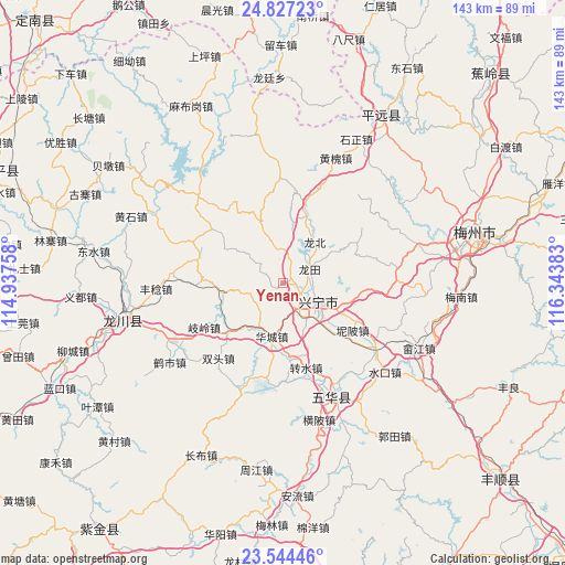
Yenan GPS coordinates[2]
24° 11' 14.856" North, 115° 38' 26.52" East
| Map corner | latitude | longitude |
|---|---|---|
| Upper-left | 24.82723°, | 114.93758° |
| Center: | 24.18746°, | 115.6407° |
| Lower-right: | 23.54446°, | 116.34383° |
| Map W x H: | 142.6×142.6 km | = 88.6×88.6mi |
| max Lat: | 53.31946° ⇑89.7% North |
| Yenan: | 24.18746° |
| min Lat: | ⇓10.3% South 18.22056° |
| min Long | Yenan | max Long |
| 75.07348° | 115.6407° | 134.28917° |
| W 57.8%⇐ | ⇒42.2% E |
Elevation
Elevation of Yenan is 134 m = 440 ft, and this is 350.8 m = 1151 ft below average elevation for this country.
| Max E: |
5622 m = 18445 ft | 54.6% |
| Avg. | 484.8 m = 1591 ft | |
| Yenan | 134 m = 440 ft | |
Min E: |
-3 m = -10 ft | 45.4% |
See also: China elevation on elevation.city.
Geographical zone
Yenan is located in North temperate zone (between Tropic of Cancer and the Arctic Circle). Distance of this Northern Tropic circle is 83.5 km =51.9 mi to South.| Distance of | km | miles | from Yenan |
|---|---|---|---|
| North Pole | 7317.7 | 4547 | to North |
| Arctic Circle | 4711.8 | 2927.8 | to North |
| Tropic Cancer | 83.5 | 51.9 | to South |
| Equator | 2689.4 | 1671.1 | to South |


Nearby cities:
15 places around Yenan: (largest is in red/bold)
• Diaofang
14.9 km =9.3 mi,  131°
131°
• Fuxing
10.5 km =6.5 mi, 129°
• Heshui
9 km =5.6 mi,  40°
40°
• Huacheng
13.7 km =8.5 mi,  191°
191°
• Longbei
13.7 km =8.5 mi, 38°
• Longtian
7.8 km =4.8 mi,  63°
63°
• Ningtang
10.9 km =6.8 mi,  97°
97°
• Ningxin
12.8 km =8 mi,  115°
115°
• Ningzhong
11 km =6.8 mi,  109°
109°
• Pingyang
15.7 km =9.8 mi,  10°
10°
• Tiechang
15.4 km =9.6 mi,  260°
260°
• Xinbei
5.9 km =3.7 mi, 123°
• Xingning
9.4 km =5.8 mi, 117°
• Xinqiao
8.3 km =5.2 mi,  242°
242°
• Yetang
2.3 km =1.4 mi,  70°
70°
Sources, notices
• [Note1] Compared only with cities in China existing in our database
• [Src1] Map data: © OpenStreetMap contributors (CC-BY-SA)
• [Src2] Other city data from geonames.org with taken over terms of usage.
• [Src3] Geographical zone / Annual Mean Temperature by Robert A. Rohde @ Wikipedia
