Tiechang geodata
Tiechang (Guangdong) is a seat of a fourth-order administrative division; located in China in Asia/Shanghai (GMT+8) time zone. In our database, there are 1268 cities with bigger population. Compared to other cities in China, 89.8% of cities are located further ↑North; 57% of cities are located further ←West and 52.9% of cities have higher elevation than Tiechang. Note1


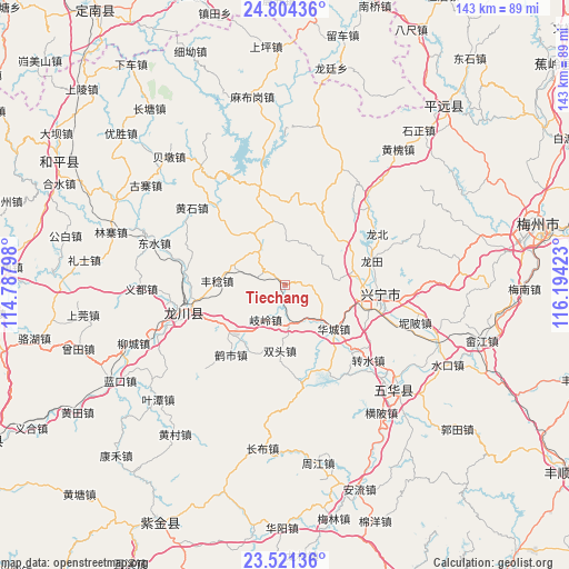
Tiechang GPS coordinates[2]
24° 9' 52.092" North, 115° 29' 27.96" East
| Map corner | latitude | longitude |
|---|---|---|
| Upper-left | 24.80436°, | 114.78798° |
| Center: | 24.16447°, | 115.4911° |
| Lower-right: | 23.52136°, | 116.19423° |
| Map W x H: | 142.7×142.7 km | = 88.7×88.7mi |
| max Lat: | 53.31946° ⇑89.8% North |
| Tiechang: | 24.16447° |
| min Lat: | ⇓10.2% South 18.22056° |
| min Long | Tiechang | max Long |
| 75.07348° | 115.4911° | 134.28917° |
| W 57%⇐ | ⇒43% E |
Elevation
Elevation of Tiechang is 144 m = 472 ft, and this is 340.8 m = 1118 ft below average elevation for this country.
| Max E: |
5622 m = 18445 ft | 52.9% |
| Avg. | 484.8 m = 1591 ft | |
| Tiechang | 144 m = 472 ft | |
Min E: |
-3 m = -10 ft | 47.1% |
See also: China elevation on elevation.city.
Geographical zone
Tiechang is located in North temperate zone (between Tropic of Cancer and the Arctic Circle). Distance of this Northern Tropic circle is 80.9 km =50.3 mi to South.| Distance of | km | miles | from Tiechang |
|---|---|---|---|
| North Pole | 7320.2 | 4548.6 | to North |
| Arctic Circle | 4714.3 | 2929.3 | to North |
| Tropic Cancer | 80.9 | 50.3 | to South |
| Equator | 2686.8 | 1669.5 | to South |


Nearby cities:
15 places around Tiechang: (largest is in red/bold)
• Daping
20.2 km =12.6 mi,  26°
26°
• Dengyun
14.5 km =9 mi,  223°
223°
• Fengren
16.7 km =10.4 mi,  273°
273°
• Guqian
7 km =4.3 mi,  286°
286°
• Huacheng
16.5 km =10.3 mi,  131°
131°
• Longmu
12.4 km =7.7 mi,  332°
332°
• Qiling
9.3 km =5.8 mi,  208°
208°
• Shizikeng
12.4 km =7.7 mi,  225°
225°
• Shuangtou
15.8 km =9.8 mi,  182°
182°
• Tianxin
11.1 km =6.9 mi,  359°
359°
• Tongqu
17.4 km =10.8 mi, 222°
• Xinbei
20.1 km =12.5 mi,  91°
91°
• Xinqiao
7.9 km =4.9 mi,  99°
99°
• Yenan
15.4 km =9.6 mi,  80°
80°
• Yetang
17.7 km =11 mi, 79°
Sources, notices
• [Note1] Compared only with cities in China existing in our database
• [Src1] Map data: © OpenStreetMap contributors (CC-BY-SA)
• [Src2] Other city data from geonames.org with taken over terms of usage.
• [Src3] Geographical zone / Annual Mean Temperature by Robert A. Rohde @ Wikipedia
