Xintang geodata
Xintang (Guangdong) is a seat of a fourth-order administrative division; located in China in Asia/Shanghai (GMT+8) time zone. In our database, there are 1268 cities with bigger population. Compared to other cities in China, 90.6% of cities are located further ↑North; 64.8% of cities are located further ←West and 53.4% of cities have higher elevation than Xintang. Note1


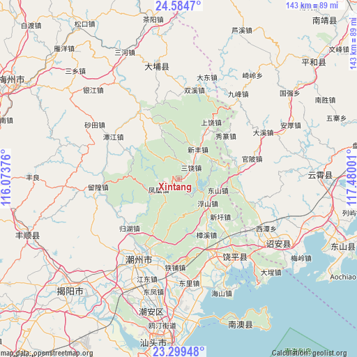
Xintang GPS coordinates[2]
23° 56' 37.284" North, 116° 46' 36.768" East
| Map corner | latitude | longitude |
|---|---|---|
| Upper-left | 24.5847°, | 116.07376° |
| Center: | 23.94369°, | 116.77688° |
| Lower-right: | 23.29948°, | 117.48001° |
| Map W x H: | 142.9×142.9 km | = 88.8×88.8mi |
| max Lat: | 53.31946° ⇑90.6% North |
| Xintang: | 23.94369° |
| min Lat: | ⇓9.4% South 18.22056° |
| min Long | Xintang | max Long |
| 75.07348° | 116.77688° | 134.28917° |
| W 64.8%⇐ | ⇒35.2% E |
Elevation
Elevation of Xintang is 141 m = 463 ft, and this is 343.8 m = 1128 ft below average elevation for this country.
| Max E: |
5622 m = 18445 ft | 53.4% |
| Avg. | 484.8 m = 1591 ft | |
| Xintang | 141 m = 463 ft | |
Min E: |
-3 m = -10 ft | 46.6% |
See also: China elevation on elevation.city.
Geographical zone
Xintang is located in North temperate zone (between Tropic of Cancer and the Arctic Circle). Distance of this Northern Tropic circle is 56.4 km =35 mi to South.| Distance of | km | miles | from Xintang |
|---|---|---|---|
| North Pole | 7344.8 | 4563.8 | to North |
| Arctic Circle | 4738.9 | 2944.6 | to North |
| Tropic Cancer | 56.4 | 35 | to South |
| Equator | 2662.3 | 1654.3 | to South |


Nearby cities:
15 places around Xintang: (largest is in red/bold)
• Dongshan
15.9 km =9.9 mi,  104°
104°
• Fenghuang
8.8 km =5.5 mi,  243°
243°
• Fubin
13.7 km =8.5 mi,  143°
143°
• Fushan
14.8 km =9.2 mi,  132°
132°
• Guangde
22.7 km =14.1 mi,  348°
348°
• Jianrao
15.9 km =9.9 mi,  58°
58°
• Raoyang
20.1 km =12.5 mi,  29°
29°
• Sanrao
6.5 km =4 mi,  45°
45°
• Tangxi
9.9 km =6.2 mi,  118°
118°
• Tanshan
21.5 km =13.4 mi,  296°
296°
• Taoyuan
20.9 km =13 mi,  319°
319°
• Wenci
22.1 km =13.7 mi,  208°
208°
• Xiage
24.5 km =15.2 mi,  76°
76°
• Xinfeng
14.4 km =8.9 mi, 33°
• Xinxu
21.8 km =13.5 mi, 130°
Sources, notices
• [Note1] Compared only with cities in China existing in our database
• [Src1] Map data: © OpenStreetMap contributors (CC-BY-SA)
• [Src2] Other city data from geonames.org with taken over terms of usage.
• [Src3] Geographical zone / Annual Mean Temperature by Robert A. Rohde @ Wikipedia
